DJI Terra has become one of the most important software solutions for professionals working with DJI drones, aerial mapping, 3D reconstruction, LiDAR data and digital site documentation. In 2026, the question is no longer simply whether DJI Terra can create maps or 3D models. The real question is whether DJI Terra is worth the investment compared with other photogrammetry and drone mapping platforms.
The answer depends on your workflow. If you already use DJI Enterprise drones and need a streamlined solution for 2D mapping, 3D reconstruction, LiDAR processing and advanced visualization, DJI Terra can be a very strong choice. However, it is not the perfect solution for every user. Some professionals may need more open workflows, broader camera compatibility, different licensing options or advanced editing tools outside the DJI ecosystem.
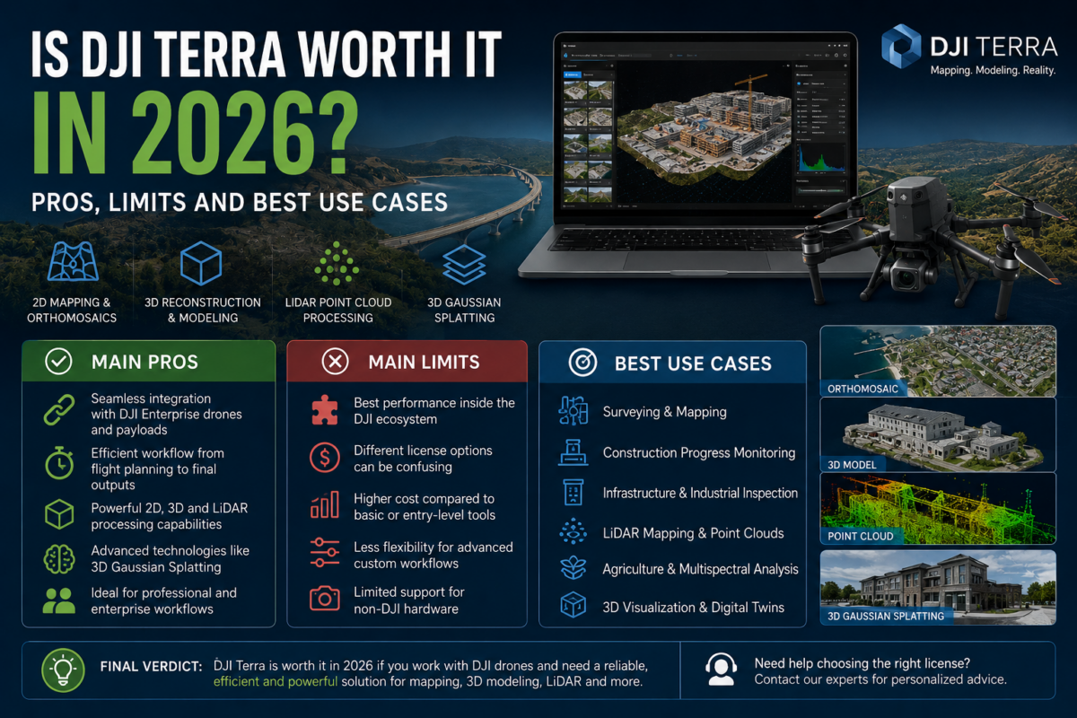
In this article, we analyze the real pros, limits and best use cases of DJI Terra in 2026, helping you understand whether it is the right software for your business, your drone fleet and your projects.
What Is DJI Terra?
DJI Terra is DJI’s professional software platform for drone data processing, 2D reconstruction, 3D reconstruction, LiDAR point cloud processing and digital model creation. It is designed to work closely with DJI Enterprise drones and DJI payloads, giving users an integrated workflow from data acquisition to final deliverables.
For many professionals, the main advantage of DJI Terra is the connection between hardware and software. DJI controls the drone, the sensor ecosystem and the processing software, which can make the workflow more direct and easier to manage. This is especially useful for companies that already operate DJI drones for mapping, surveying, inspection, public safety, construction or agriculture.
DJI Terra can be used to generate outputs such as orthomosaics, 3D models, point clouds, digital surface models, LiDAR reconstructions and visual products for technical analysis. In the latest versions, DJI Terra also includes advanced reconstruction technologies such as 3D Gaussian Splatting, which is becoming increasingly relevant for photorealistic 3D visualization.
Is DJI Terra Worth It in 2026?
Yes, DJI Terra can be worth it in 2026, especially if your business is already based on DJI Enterprise drones and you need a professional tool for aerial data processing. It is particularly valuable when you want an efficient workflow, strong DJI ecosystem integration and reliable outputs for mapping, modeling, LiDAR or inspection-related projects.
However, DJI Terra is not automatically the best option for everyone. If you use many different non-DJI cameras, need highly customized photogrammetry workflows, or require advanced editing and processing flexibility beyond the DJI ecosystem, you should compare it carefully with other solutions before deciding.
The strongest reason to choose DJI Terra is efficiency. If your field team captures data with DJI drones and your office team needs to process that data quickly into usable outputs, DJI Terra can reduce complexity. Instead of combining many different tools, file formats and processing steps, you can stay within a more unified DJI workflow.
Main Pros of DJI Terra
1. Strong Integration with DJI Enterprise Drones
The biggest advantage of DJI Terra is its natural integration with DJI hardware. If you use DJI Enterprise drones, DJI Terra can make the overall workflow easier to understand and manage. This is particularly important for companies that need repeatable production, standardized procedures and fewer technical obstacles between flight and final output.
For teams working with DJI drones such as Mavic Enterprise platforms, Matrice series aircraft or DJI LiDAR payloads, Terra can become a central processing hub. This is one of the reasons why it is often considered by surveyors, inspection companies and industrial drone operators.
2. Good Solution for 2D Mapping and Orthomosaics
DJI Terra is suitable for creating 2D maps and orthomosaics from drone imagery. This makes it useful for land documentation, construction progress monitoring, agriculture, public works, quarry monitoring and other professional mapping applications.
For many users, 2D mapping is still the most important deliverable. Clients often need a clear, updated and measurable aerial view of a site. DJI Terra can help turn captured drone images into practical outputs that can be used for planning, reporting and decision-making.
3. 3D Reconstruction and Visual Modeling
DJI Terra is also valuable for 3D reconstruction. It can be used to create 3D models of buildings, infrastructure, terrain, construction sites and other real-world assets. This makes it useful not only for technical mapping but also for visual communication.
In 2026, 3D models are becoming more important across many industries. Construction companies use them to document progress. Inspection teams use them to understand complex structures. Public agencies use them for planning and monitoring. Real estate, cultural heritage and industrial users can also benefit from better 3D visualization.
4. LiDAR Data Processing with DJI Payloads
Another important advantage of DJI Terra is its support for data collected by DJI LiDAR systems. LiDAR workflows are increasingly relevant for surveying, forestry, powerline inspection, infrastructure mapping and terrain modeling.
For professionals using DJI LiDAR payloads, DJI Terra can simplify the processing of point clouds and related outputs. This is especially useful when working in environments where photogrammetry alone may not be sufficient, such as vegetation, complex terrain or structures requiring dense 3D data.
5. Advanced Reconstruction Technologies
DJI Terra has evolved beyond traditional mapping. With newer reconstruction technologies such as 3D Gaussian Splatting, DJI is positioning Terra as a more advanced 3D modeling and visualization solution.
Gaussian Splatting is especially interesting for users who want more realistic 3D representations of real-world scenes. It can be valuable for cultural heritage, digital twins, visual inspection, real estate, infrastructure documentation and immersive 3D visualization.
6. Suitable for Enterprise Workflows
DJI Terra can be a good fit for enterprise teams that need structured drone data processing. Companies often prefer tools that are easier to deploy, easier to train and easier to standardize across teams.
If a company already owns DJI drones and wants to build a repeatable mapping workflow, DJI Terra can reduce the number of separate software platforms needed. This can help with training, support, internal documentation and operational efficiency.
Main Limits of DJI Terra
1. Best Value Inside the DJI Ecosystem
DJI Terra is strongest when used with DJI drones and DJI sensors. This is an advantage for DJI users, but it can be a limitation for companies with mixed drone fleets or non-DJI cameras.
If your workflow includes many different sensors, cameras, drones or custom capture systems, you may need to check carefully whether DJI Terra fits your requirements. Some users may prefer more platform-independent photogrammetry software for highly customized projects.
2. Licensing Can Be Confusing
DJI Terra is available in different license options and packages, including versions such as Standard, Flagship, Agriculture, Cluster and combinations with DJI Modify, depending on market availability. This can make the buying decision more complex for new users.
Before purchasing, it is important to understand which version includes the features you actually need. Buying the wrong license can lead to unnecessary costs or missing functionality.
3. Not Always the Cheapest Option
DJI Terra is a professional software platform, and professional software has a cost. For occasional users or beginners who only need basic mapping, the investment may feel high compared with lighter or simpler tools.
However, price should be evaluated in relation to productivity. If DJI Terra saves time, reduces workflow complexity and helps you deliver better outputs to clients, the software can justify its cost. If you only process a few small projects per year, you should calculate the return on investment carefully.
4. Advanced Users May Need More Flexibility
Some advanced photogrammetry professionals may want deeper control over processing parameters, scripting, custom coordinate workflows, non-standard datasets or highly specialized outputs. In these cases, DJI Terra should be compared with other professional tools before choosing it as the main production platform.
DJI Terra is excellent for many DJI-based workflows, but not every technical user wants an ecosystem-driven solution. Some companies may prefer more open or customizable software depending on their project type.
Best Use Cases for DJI Terra in 2026
1. Drone Surveying and Mapping
DJI Terra is a strong option for drone surveying and mapping, especially for users working with DJI Enterprise drones. It can support workflows involving orthomosaics, 3D models, terrain documentation and site analysis.
Surveyors can use DJI Terra to process aerial imagery into practical outputs for land measurement, planning, construction documentation and environmental monitoring. For many standard mapping projects, DJI Terra provides an efficient and logical workflow.
2. Construction Progress Monitoring
Construction companies can benefit from DJI Terra by regularly documenting job sites from the air. Orthomosaics and 3D models can help teams compare progress over time, communicate with stakeholders and identify changes on site.
This is one of the most practical use cases because it does not always require extremely complex deliverables. The value comes from repeatability, speed and clear visual documentation.
3. Infrastructure and Industrial Inspection
DJI Terra can be useful for infrastructure and industrial inspection workflows, especially when combined with DJI drones and suitable payloads. Bridges, towers, powerlines, industrial plants, roads and large facilities can all benefit from drone-based digital documentation.
For advanced inspection scenarios, users should carefully evaluate which DJI Terra license is required. More complex workflows may require higher-tier features and more complete software capabilities.
4. LiDAR Mapping and Point Cloud Processing
LiDAR is one of the most important reasons to consider DJI Terra. For users working with DJI LiDAR payloads, Terra can provide a more direct route from captured data to processed point cloud outputs.
This is particularly valuable for forestry, terrain modeling, utility corridors, complex topography and projects where vegetation or structure complexity makes traditional photogrammetry more difficult.
5. Agriculture and Multispectral Mapping
DJI Terra can also support agriculture-related workflows, especially when used with compatible multispectral data. Farmers, agronomists and agricultural service providers may use drone data to monitor crop conditions, identify stress patterns and support decision-making.
For agricultural users, the key question is whether DJI Terra provides the required outputs and whether the chosen license matches the intended workflow.
6. 3D Visualization and Digital Twin Projects
With the rise of more advanced 3D reconstruction methods, DJI Terra is becoming more interesting for visual 3D projects and digital twin-style applications. Photorealistic models can help communicate complex sites more effectively than traditional maps alone.
This can be useful for real estate, tourism, cultural heritage, infrastructure, urban planning, industrial documentation and internal corporate reporting.
Who Should Choose DJI Terra?
DJI Terra is a good choice for drone professionals, surveyors, construction companies, inspection teams, public agencies, agricultural service providers and enterprise users who already rely on DJI hardware and want an integrated software workflow.
You should consider DJI Terra if:
- You use DJI Enterprise drones for professional projects
- You need 2D maps, orthomosaics or 3D models
- You work with DJI LiDAR payloads
- You want a streamlined workflow from flight to output
- You need professional deliverables for clients or internal teams
- You want to explore advanced 3D reconstruction and visualization
Who Should Compare Alternatives Before Buying?
You should compare DJI Terra with other software solutions if your workflow is not strongly connected to DJI hardware, if you need broad non-DJI camera support, or if you require highly customizable photogrammetry processing.
You should also compare alternatives if you mainly need low-cost occasional processing, cloud-only collaboration, advanced scripting automation or a workflow that must support many different sensor brands.
DJI Terra Pros and Limits Summary
| Category | Pros | Limits |
|---|---|---|
| DJI Ecosystem | Excellent integration with DJI drones and sensors | Less ideal for mixed non-DJI workflows |
| 2D Mapping | Strong for orthomosaics and site maps | License choice must match required outputs |
| 3D Reconstruction | Useful for models, visualization and digital documentation | Advanced features may require higher-tier licenses |
| LiDAR | Good fit for DJI LiDAR payload workflows | Best suited to DJI-compatible data |
| Cost | Can save time in professional workflows | May be expensive for occasional users |
| Enterprise Use | Good for repeatable and standardized operations | Advanced teams may need to compare flexibility |
Final Verdict: Is DJI Terra Worth It?
DJI Terra is worth it in 2026 if you use DJI Enterprise drones and need a professional, integrated solution for drone mapping, 3D reconstruction, LiDAR processing or digital site documentation. Its biggest strengths are workflow efficiency, DJI ecosystem integration and its growing set of advanced reconstruction capabilities.
For drone service providers, surveyors, construction companies, inspection teams and enterprise users, DJI Terra can be a valuable investment. It can reduce complexity, improve productivity and help transform aerial data into useful deliverables.
However, DJI Terra is not the best choice for every situation. If your work depends on non-DJI hardware, highly customized photogrammetry workflows or occasional low-volume processing, it is worth comparing different software options before purchasing.
In simple terms, DJI Terra is most valuable when the software is part of a complete DJI professional workflow. If your drones, sensors and projects are already aligned with the DJI ecosystem, DJI Terra can be one of the most practical choices available in 2026.
Need help choosing the right DJI Terra license? Contact our team for professional advice. We can help you compare DJI Terra Standard, Flagship, Agriculture, Cluster and DJI Modify options based on your drone model, project type and required outputs.
FAQ: Is DJI Terra Worth It in 2026?
Is DJI Terra good for professional drone mapping?
Yes, DJI Terra is a strong solution for professional drone mapping, especially for users working with DJI Enterprise drones and DJI-compatible workflows.
Is DJI Terra suitable for beginners?
DJI Terra can be suitable for beginners who already use DJI drones, but it is still a professional tool. New users should learn the basics of drone mapping, image capture, overlap, ground control points and output accuracy.
Can DJI Terra create 3D models?
Yes, DJI Terra can be used for 3D reconstruction and model generation. Depending on the license and workflow, it can support different levels of 3D modeling and visualization.
Is DJI Terra useful for LiDAR?
Yes, DJI Terra is particularly useful for users working with DJI LiDAR payloads. It can help process LiDAR data and generate point cloud outputs for professional applications.
Is DJI Terra only for DJI drones?
DJI Terra is designed primarily around the DJI ecosystem. It is most valuable when used with DJI Enterprise drones and DJI payloads, although users should always check compatibility for their specific workflow.
What industries use DJI Terra?
DJI Terra is used in surveying, construction, infrastructure inspection, agriculture, public safety, mining, forestry, real estate, cultural heritage and industrial documentation.
Should I choose DJI Terra Standard or Flagship?
DJI Terra Standard is suitable for many mapping and standard reconstruction workflows. DJI Terra Flagship is better for advanced 3D, LiDAR, inspection and enterprise-level projects.
Is DJI Terra worth the price?
DJI Terra is worth the price if it saves time, simplifies your workflow and helps you deliver professional outputs more efficiently. Occasional users should calculate whether the license cost matches their project volume.