Choosing the right DJI Terra license is one of the most important decisions for drone professionals who want to turn aerial data into accurate digital outputs. Whether you work in surveying, construction, infrastructure inspection, public safety, agriculture, or 3D modeling, DJI Terra can become a central part of your mapping workflow. However, many users are unsure about one key question: should they choose DJI Terra Standard or DJI Terra Flagship?
The answer depends on your projects, your drone fleet, your expected deliverables and the level of advanced reconstruction you need. DJI Terra Standard is generally suitable for many professional mapping and modeling tasks, while DJI Terra Flagship is designed for users who need a more complete feature set, especially for advanced 3D workflows, high-value industrial applications and next-generation reconstruction technologies.
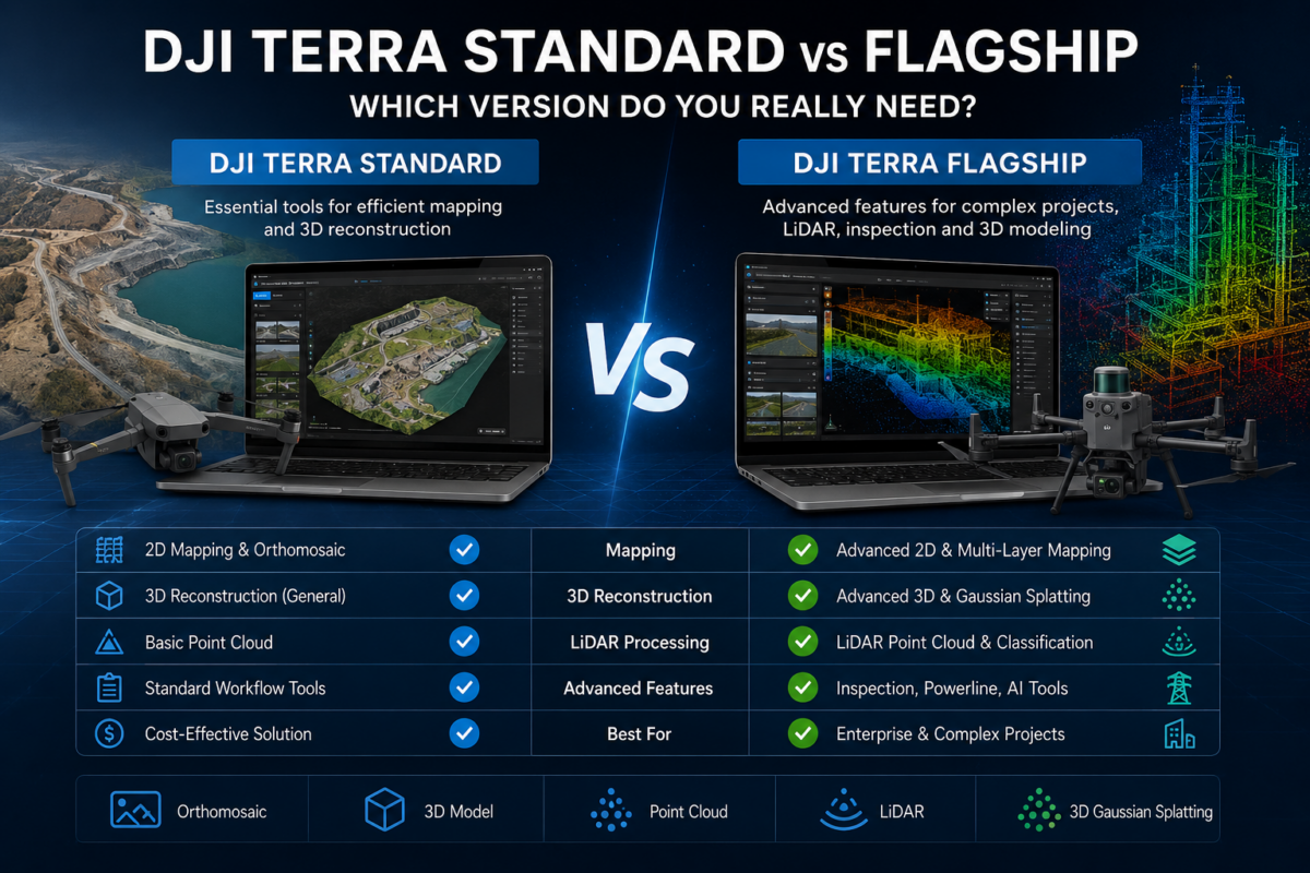
In this guide, we compare DJI Terra Standard vs Flagship in a practical way, helping you understand which version makes more sense for your business before purchasing a license.
What Is DJI Terra?
DJI Terra is DJI’s professional software platform for drone mapping, 2D reconstruction, 3D reconstruction, LiDAR data processing and digital model generation. It is designed to work closely with DJI Enterprise drones and payloads, creating a more integrated workflow from flight planning and data capture to processing and final output.
For many drone operators, the biggest advantage of DJI Terra is this ecosystem integration. If you are already using DJI aircraft such as the Mavic 3 Enterprise series, Matrice platforms, Zenmuse LiDAR sensors or other DJI Enterprise solutions, DJI Terra can simplify the path from raw drone data to usable deliverables.
Typical outputs may include orthomosaics, digital surface models, 3D models, point clouds, inspection data, reconstruction projects and mapping products for GIS, CAD, construction monitoring or infrastructure analysis.
DJI Terra Standard: Who Is It For?
DJI Terra Standard is usually the best choice for professionals who need a reliable drone mapping and reconstruction solution without necessarily requiring every advanced feature available in the highest license tier.
This version is a strong option for users focused on traditional drone mapping workflows. If your main work involves creating orthomosaics, 2D maps, 3D models from visible-light images, construction site documentation, land surveys, progress monitoring or general photogrammetry projects, Standard may already cover most of your daily needs.
DJI Terra Standard is particularly attractive for small and medium-sized drone service providers, engineering offices, construction companies, real estate mapping teams and public safety departments that need professional results but want to control software costs.
Typical DJI Terra Standard Use Cases
- 2D map reconstruction from drone images
- 3D model generation for buildings, construction sites and terrain
- Orthomosaic creation for surveying and documentation
- Basic professional mapping workflows with DJI drones
- Construction progress monitoring
- Urban mapping and site documentation
- General drone photogrammetry projects
If your business mainly needs accurate and repeatable mapping outputs, DJI Terra Standard can be a cost-effective entry point into the DJI Terra ecosystem.
DJI Terra Flagship: Who Is It For?
DJI Terra Flagship is designed for more demanding professional environments. It is the version to consider when your projects go beyond standard mapping and require advanced reconstruction, more specialized applications, or high-end 3D visualization workflows.
Flagship is generally better suited for organizations working with complex industrial data, infrastructure inspection, high-quality 3D model production, powerline or utility-related workflows, advanced LiDAR processing, or next-generation 3D reconstruction such as Gaussian Splatting where available.
This version is especially relevant for enterprise users who need to deliver premium outputs to clients, public authorities, engineering departments or internal technical teams. If the software is not only used occasionally but becomes a key part of your production pipeline, Flagship may be the safer long-term investment.
Typical DJI Terra Flagship Use Cases
- Advanced 3D reconstruction projects
- High-value infrastructure inspection
- Powerline, utility and industrial inspection workflows
- More complex LiDAR and point cloud processing scenarios
- Premium visualization and digital twin-style outputs
- Large professional drone mapping operations
- Projects requiring the most complete DJI Terra feature set
In simple terms, DJI Terra Flagship is aimed at users who do not want to be limited by the software tier and prefer to have access to the most advanced capabilities available in the DJI Terra lineup.
Standard vs Flagship: The Main Difference
The main difference between DJI Terra Standard and DJI Terra Flagship is not simply “basic vs professional.” Both versions are professional tools. The real difference is the depth of available functions and the type of workflows each version is designed to support.
Standard is usually the right choice for common mapping, modeling and reconstruction tasks. Flagship becomes more important when you need advanced 3D capabilities, specialized inspection workflows, enhanced reconstruction options or the most complete version for enterprise use.
| Feature / Use Case | DJI Terra Standard | DJI Terra Flagship |
|---|---|---|
| General 2D Mapping | Suitable | Suitable |
| Standard 3D Reconstruction | Suitable for many projects | Suitable for advanced projects |
| Drone Surveying | Good choice for many users | Best for demanding workflows |
| Industrial Inspection | Possible depending on requirements | Recommended for advanced inspection |
| Advanced 3D / Digital Twin Workflows | Limited compared to Flagship | Recommended |
| High-End Enterprise Use | Good for standard production | Best long-term option |
When DJI Terra Standard Is Enough
DJI Terra Standard is likely enough if your work is mainly based on regular mapping and photogrammetry deliverables. For example, if you fly a DJI Enterprise drone, collect nadir or oblique images, process them into orthomosaics or 3D models, and deliver standard outputs to clients, Standard can be the most rational choice.
You should consider DJI Terra Standard if:
- You mainly create 2D maps and orthomosaics
- You need 3D models for documentation rather than advanced visualization
- You are starting a drone mapping business
- You want to keep the initial software investment lower
- Your projects are not focused on advanced powerline or industrial inspection
- You do not need the most advanced reconstruction technologies
For many small drone companies, Standard can provide the right balance between capability and cost. It allows you to enter the DJI Terra ecosystem without overpaying for functions you may not use immediately.
When DJI Terra Flagship Is the Better Choice
DJI Terra Flagship becomes the better option when drone data processing is a core part of your business and you need the most complete toolset available. If your clients expect advanced outputs, if you work with critical infrastructure, or if you need to handle more complex 3D and inspection workflows, Flagship can reduce the risk of outgrowing your license too quickly.
You should consider DJI Terra Flagship if:
- You work with complex 3D reconstruction projects
- You need advanced inspection capabilities
- You process data for utilities, infrastructure or industrial assets
- You want access to high-end DJI Terra features
- You are building an enterprise mapping workflow
- You want a more future-proof license choice
Flagship is also easier to justify when the software is used frequently by your team. If DJI Terra is central to your revenue-generating activity, the additional investment may be small compared with the value of better workflows, broader capabilities and fewer software limitations.
Cost Consideration: Do Not Buy More Than You Need
The most expensive license is not always the best license. The right DJI Terra version is the one that matches your real operational needs. If you only need standard orthomosaics and 3D models, buying Flagship too early may not provide an immediate return on investment.
On the other hand, choosing Standard only because it costs less can become a limitation if your projects soon require advanced 3D reconstruction, specialized inspection features or premium outputs. In that case, starting with Flagship may save time and avoid workflow interruptions later.
The best approach is to evaluate your current projects and your expected projects over the next 12 to 24 months. If your work is growing toward larger, more complex and more technical deliverables, Flagship deserves serious consideration.
DJI Terra Standard vs Flagship for Surveying
For many surveying applications, DJI Terra Standard can be sufficient. If your main deliverables are orthomosaics, 3D models, terrain documentation and visual site analysis, Standard can be a practical and efficient solution.
However, surveying companies that handle large infrastructure corridors, utility assets, complex sites or advanced 3D deliverables may prefer Flagship. The more technical and demanding the project becomes, the more valuable the advanced license tier may be.
DJI Terra Standard vs Flagship for Construction
Construction companies often need regular progress monitoring, site maps, volume documentation and 3D models for internal communication. For this type of workflow, Standard may be enough for many teams.
Flagship becomes more interesting for larger construction groups, infrastructure contractors or engineering companies that need high-quality 3D deliverables, detailed asset inspection or more advanced reconstruction workflows.
DJI Terra Standard vs Flagship for Inspection
If your work involves simple visual documentation, DJI Terra Standard may be suitable. But if you are working with industrial sites, powerlines, utilities, towers, bridges or complex structures, Flagship is usually the more appropriate option.
Inspection workflows often require more than just a basic map. They may involve detailed 3D context, repeatable data processing, advanced visualization and technical outputs that support decision-making. In these cases, investing in the higher license tier may be justified.
Which Version Should You Buy?
Choose DJI Terra Standard if you need a professional and cost-effective solution for everyday drone mapping, 2D reconstruction and standard 3D modeling. It is a good choice for many drone service providers, construction teams, surveyors and organizations that want reliable results without paying for features they may not use.
Choose DJI Terra Flagship if you need the most complete version, advanced reconstruction capabilities, industrial inspection workflows or a more future-proof solution for enterprise projects. It is the better choice for companies that rely heavily on DJI Terra for technical production and client deliverables.
In short: Standard is the smart choice for regular professional mapping. Flagship is the smart choice for advanced professional production.
Final Verdict
DJI Terra Standard and DJI Terra Flagship are both powerful options, but they serve different types of users. Standard is ideal for professionals who need solid mapping and reconstruction tools at a more accessible level. Flagship is designed for users who need advanced capabilities, broader workflow coverage and maximum flexibility inside the DJI Terra ecosystem.
If your projects are simple, repetitive and mostly based on standard mapping deliverables, DJI Terra Standard may be all you need. If your work involves complex 3D reconstruction, LiDAR, industrial inspection, utility applications or high-end deliverables, DJI Terra Flagship is likely the better long-term investment.
Need help choosing the right DJI Terra license? Contact our team for professional guidance. We can help you compare DJI Terra Standard and DJI Terra Flagship based on your drone model, workflow, project size and expected outputs.
FAQ: DJI Terra Standard vs Flagship
Is DJI Terra Standard enough for drone mapping?
Yes, DJI Terra Standard can be enough for many drone mapping workflows, especially if you mainly need 2D maps, orthomosaics and standard 3D reconstruction.
Who should buy DJI Terra Flagship?
DJI Terra Flagship is recommended for advanced users, enterprise teams, industrial inspection professionals and companies that need the most complete DJI Terra feature set.
Is DJI Terra Flagship better than Standard?
Flagship is more complete, but that does not mean every user needs it. Standard may be the better value if your projects do not require advanced features.
Can DJI Terra be used with DJI Enterprise drones?
Yes, DJI Terra is designed to integrate with DJI Enterprise workflows and is commonly used with DJI drones for mapping, modeling and inspection projects.
Which DJI Terra version is best for construction?
For regular construction progress monitoring and mapping, Standard may be enough. For larger infrastructure projects or advanced 3D deliverables, Flagship may be a better choice.
Which DJI Terra version is best for inspection?
For basic visual documentation, Standard may work. For industrial, utility, powerline or complex infrastructure inspection, Flagship is usually the stronger choice.
Should I start with Standard and upgrade later?
This can be a good strategy if you are starting with basic mapping projects. However, if you already know that your work requires advanced 3D or inspection capabilities, starting with Flagship may be more efficient.