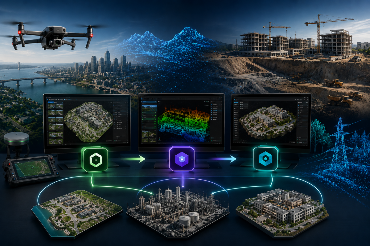
DJI is no longer focused only on drones. In 2026, the company is increasingly building a complete ecosystem for drone mapping, 3D reconstruction, model editing and visualization. With DJI Terra, DJI Modify and DJI Reality, the workflow is becoming much broader than simple flight planning or orthomosaic generation. DJI appears to be moving toward a full reality capture pipeline: capture data with DJI drones, process it in DJI Terra, refine it in DJI Modify and visualize it with DJI Reality.
This is a major shift for drone mapping professionals, surveyors, construction companies, inspection teams and enterprise users. Until recently, many professionals had to combine different tools for each stage of the workflow. One platform was used for photogrammetry, another for point cloud cleaning, another for mesh repair and another for client visualization. DJI now seems to be connecting these steps inside a more unified software ecosystem.
The official DJI download page lists a package that includes DJI Terra V5.2.0, DJI Modify V1.6.0 and DJI Reality V1.0.0. This is important because it shows that DJI is not treating these products as isolated tools. Instead, they are becoming part of a connected workflow for 3D mapping, model refinement and reality visualization.
In this article, we analyze what DJI Terra, DJI Modify and DJI Reality do, how they work together and why this may matter for the future of professional drone mapping.
What Is DJI Terra?
DJI Terra is DJI’s professional software for 2D mapping, 3D reconstruction, LiDAR point cloud processing and advanced modeling workflows. It is designed to work with DJI Enterprise drones and payloads, helping users transform aerial data into usable digital outputs.
DJI describes Terra as 3D modeling software equipped with next-generation reconstruction technologies, including 3D Gaussian Splatting. It supports 2D and 3D reconstruction from visible-light imagery and can process data collected by DJI LiDAR systems. When used with DJI drones, Terra creates a more unified hardware and software solution for aerial surveying workflows.
For professionals, DJI Terra is the processing engine of the ecosystem. It is where drone images, LiDAR data and reconstruction projects are transformed into outputs such as orthomosaics, point clouds, 3D models and photorealistic reconstructions.
What Is DJI Modify?
DJI Modify is DJI’s intelligent 3D model editing software. Its purpose is to help users clean, repair and optimize 3D models and point clouds after reconstruction. This is an important step because raw 3D reconstruction is rarely perfect. Even high-quality drone datasets can produce floating objects, holes, irregular surfaces, water artifacts, vehicle artifacts or messy point cloud areas.
DJI officially describes Modify as its first intelligent 3D model editing software, designed for simplicity, intuitiveness and efficiency. The software supports operations such as point cloud smoothing, noise reduction, downsampling, classification, point cloud category adjustment, terrain result generation and 3D mesh defect repair.
This makes DJI Modify the refinement layer of the ecosystem. DJI Terra creates the model. DJI Modify helps improve it. For professionals delivering client-ready 3D products, this step can be essential.
What Is DJI Reality?
DJI Reality is the newest and most strategic part of the ecosystem. It is positioned as a viewer for visualizing 3D mapping outputs such as mesh models, 3D Gaussian Splatting projects and point clouds. The DJI download page lists DJI Reality V1.0.0 with a Windows version date of March 26, 2026, and the combined package with DJI Terra and DJI Modify was released on April 9, 2026.
DJI Reality matters because visualization is often the final stage of a drone mapping workflow. A surveyor, construction manager, real estate developer or public agency may not want to open complex processing software just to review a 3D model. They need a simple way to inspect, navigate and present the final result.
This is where DJI Reality can become valuable. If Terra is for reconstruction and Modify is for editing, Reality is for presentation and review. Together, the three tools suggest a complete pipeline from raw drone data to final 3D visualization.
Why This Looks Like a Full 3D Mapping Ecosystem
The combination of DJI Terra, DJI Modify and DJI Reality suggests that DJI is trying to cover the entire professional mapping workflow. This is not only about creating software. It is about controlling more of the value chain.
A complete 3D mapping ecosystem usually includes four stages:
- Data acquisition
- Data processing and reconstruction
- Model cleaning and optimization
- Visualization and delivery
DJI already has a strong position in the first stage through its drone hardware, cameras, RTK systems and LiDAR payloads. DJI Terra covers the second stage. DJI Modify supports the third stage. DJI Reality addresses the fourth stage.
This means DJI can potentially offer a full workflow from flight to final presentation. For many users, this could reduce the need to move between multiple software platforms.
The Full DJI 3D Mapping Workflow
| Workflow Stage | DJI Product | Main Purpose | Professional Benefit |
|---|---|---|---|
| Data Capture | DJI Enterprise drones and payloads | Collect aerial images, LiDAR data and RTK/PPK data | Integrated capture with DJI hardware |
| Processing | DJI Terra | Create 2D maps, 3D models, point clouds and 3DGS outputs | Efficient reconstruction inside DJI ecosystem |
| Editing | DJI Modify | Repair meshes, clean point clouds, remove defects and optimize models | Cleaner and more professional final deliverables |
| Visualization | DJI Reality | View mesh, point cloud and 3D reconstruction outputs | Easier model review, presentation and communication |
Why This Matters for Drone Mapping Professionals
1. Fewer Software Platforms in the Workflow
One of the biggest challenges in professional drone mapping is managing multiple software tools. A project may start with drone flight planning, continue with image or LiDAR processing, move into a model repair tool, then finish in a separate viewer or GIS platform.
Every software transition creates friction. Files must be exported, imported, converted and checked. Coordinate systems must remain consistent. Large datasets must be moved between folders and applications. Each additional tool increases training requirements and potential errors.
If DJI Terra, DJI Modify and DJI Reality work together smoothly, professionals may be able to reduce this friction. A more unified ecosystem can make the workflow faster and easier to standardize.
2. Better 3D Model Quality
Reconstruction software can create impressive models, but raw outputs often require cleanup. DJI Modify is important because it addresses this post-processing stage. It can help repair common issues such as floating parts, holes, irregular surfaces, water anomalies and unwanted objects.
This matters for professional delivery. A client may not notice the algorithm behind a reconstruction, but they will notice visible model defects. Cleaner models look more professional and are easier to use for presentation, inspection or reporting.
3. Stronger Point Cloud Workflows
Point clouds are increasingly important in drone mapping, especially for LiDAR, surveying, forestry, utilities and infrastructure projects. DJI Modify’s ability to smooth, reduce noise, downsample and classify point clouds can help professionals manage heavy datasets more efficiently.
For surveyors and engineers, point cloud quality affects downstream analysis. Cleaner data can improve interpretation, reduce manual work and help teams prepare better deliverables.
4. More Accessible 3D Visualization
One of the biggest barriers in 3D mapping is sharing results with people who are not technical specialists. A GIS manager, construction director, investor, mayor, project owner or field supervisor may not know how to use photogrammetry software. But they still need to understand the model.
DJI Reality can help fill this gap by providing a more accessible viewing environment for 3D outputs. If clients and teams can open and review models more easily, drone mapping deliverables become more useful.
5. A More Complete Digital Twin Pipeline
Digital twins are becoming more common in construction, infrastructure, energy, public safety and urban planning. A digital twin workflow requires more than data capture. It needs accurate reconstruction, model cleaning, visualization and regular updates.
DJI’s software ecosystem could support this direction. Terra processes the project, Modify improves the model and Reality helps visualize it. For companies building repeatable digital twin workflows, this integrated approach could become increasingly attractive.
DJI Terra: The Reconstruction Engine
DJI Terra is the foundation of the software ecosystem because it creates the core outputs. It supports 2D reconstruction, 3D reconstruction, LiDAR data processing and newer technologies such as 3D Gaussian Splatting.
For surveyors and mapping companies, this means Terra can be used to produce practical deliverables such as orthomosaics, digital surface models, point clouds, 3D meshes and visual reconstructions. In a complete ecosystem, Terra is where the raw data becomes a structured digital asset.
With the latest versions, DJI Terra is clearly becoming more advanced. Support for LiDAR workflows, COG GeoTIFF exports, D-RTK 3 automatic mark identification and 3DGS optimization shows that DJI is targeting serious professional users, not only casual drone pilots.
DJI Modify: The Editing and Cleanup Layer
DJI Modify is important because reconstruction is not the end of the process. Professional 3D models often need refinement before delivery. A building model may have holes. A road reconstruction may include floating artifacts. A site model may contain unwanted vehicles. Water surfaces may create visual anomalies. Point clouds may be noisy or too dense.
DJI Modify is designed to make these editing tasks simpler. By using intelligent model repair and point cloud tools, it can reduce the manual work required to clean final outputs. This is especially useful for teams that need to deliver models quickly and consistently.
For drone service providers, this can improve perceived quality. A clean model can make the difference between a basic reconstruction and a professional deliverable.
DJI Reality: The Viewer and Presentation Layer
DJI Reality may become important because final delivery is often about communication. A technically accurate model is useful, but it must also be easy to review and understand.
If DJI Reality allows users to view mesh, point cloud and 3DGS outputs in a simpler environment, it can make DJI’s mapping ecosystem more complete. It can help bridge the gap between technical processing and client presentation.
This matters for many industries:
- Construction teams reviewing job site progress
- Surveyors presenting terrain or infrastructure models
- Public agencies inspecting urban or emergency response data
- Real estate teams showing realistic 3D environments
- Industrial companies reviewing plants, assets or corridors
- Cultural heritage teams sharing digital documentation
Industries That Could Benefit from the DJI Ecosystem
Surveying and Mapping
Surveyors can benefit from an integrated workflow for data capture, reconstruction, point cloud processing and output visualization. DJI Terra and DJI Modify can reduce the amount of manual work required to create clean deliverables.
Construction and Infrastructure
Construction companies need repeatable documentation, 3D progress models and clear visual reporting. A DJI-based ecosystem can help teams capture, process, refine and present project updates more efficiently.
Public Safety
Emergency teams and public agencies can use 3D reconstructions for scene documentation, disaster response, planning and training. A simple viewing tool like DJI Reality could make these outputs easier to share internally.
Energy and Utilities
Powerlines, substations, solar farms, wind farms and industrial assets require detailed inspection. LiDAR, point clouds and 3D models can support better asset understanding and maintenance workflows.
Mining and Quarries
Mining and quarry companies need regular terrain updates, stockpile documentation and site monitoring. Integrated mapping and reconstruction tools can improve production speed and reporting consistency.
Cultural Heritage and Digital Preservation
High-quality 3D reconstruction and visualization can help document historical buildings, archaeological sites and cultural assets. DJI Reality and 3DGS-style visualization may be especially useful for presenting models to non-technical audiences.
Potential Limits of a Closed Ecosystem
While DJI’s integrated approach has many advantages, professionals should also consider potential limits. A full DJI ecosystem may work best for users who already rely on DJI drones and DJI payloads. Companies with mixed fleets, non-DJI sensors or highly customized workflows may still need additional software.
Another consideration is flexibility. Some advanced photogrammetry users need scripting, highly specialized coordinate system workflows, custom export pipelines or deep control over reconstruction parameters. Depending on project requirements, they may still prefer more open or specialized software platforms.
Therefore, DJI’s ecosystem should not be seen as automatically replacing every other tool. Instead, it should be seen as a strong integrated option for DJI-centered professional workflows.
Is DJI Building a Full 3D Mapping Ecosystem?
Yes, the direction is clear. DJI appears to be building a full 3D mapping ecosystem that covers data capture, reconstruction, editing and visualization. DJI Terra, DJI Modify and DJI Reality each address a different stage of the workflow, and their combined package suggests a strategic move toward a more unified professional software environment.
This does not mean every mapping professional will move entirely to DJI software. However, for users already committed to DJI Enterprise hardware, the ecosystem is becoming increasingly attractive. It can reduce workflow complexity, improve model quality and make 3D outputs easier to present.
Final Verdict
DJI Terra, DJI Modify and DJI Reality show that DJI is moving beyond drone hardware and into the complete reality capture workflow. DJI Terra handles mapping and reconstruction. DJI Modify improves and repairs 3D outputs. DJI Reality supports visualization and presentation.
For drone mapping professionals, this could be a significant development. A more integrated ecosystem can reduce software fragmentation, simplify training and make it easier to deliver professional results to clients.
The biggest advantage will likely be for companies already using DJI Enterprise drones, DJI LiDAR payloads and DJI Terra. For these users, the combination of Terra, Modify and Reality may become one of the most practical end-to-end 3D mapping workflows available in 2026.
Need help choosing the right DJI Terra or DJI Modify license? Contact our team for professional guidance. We can help you compare DJI Terra Standard, Flagship, Agriculture, Cluster, DJI Modify and related options based on your drone model, project type, required outputs and 3D reconstruction workflow.
FAQ: DJI Terra, DJI Modify and DJI Reality
What is DJI Terra used for?
DJI Terra is used for 2D mapping, 3D reconstruction, LiDAR point cloud processing and advanced drone data reconstruction workflows. It is especially useful for professionals working with DJI Enterprise drones and payloads.
What is DJI Modify?
DJI Modify is DJI’s intelligent 3D model editing software. It is designed to repair 3D mesh defects, clean point clouds, reduce noise, classify data, smooth models and improve final 3D deliverables.
What is DJI Reality?
DJI Reality is a 3D model viewing tool listed by DJI as part of the DJI Terra and DJI Modify software package. It is designed to support visualization and review of 3D mapping outputs such as mesh models, point clouds and 3D reconstructions.
Do DJI Terra, DJI Modify and DJI Reality work together?
Yes, DJI’s download page lists combined software packages that include DJI Terra V5.2.0, DJI Modify V1.6.0 and DJI Reality V1.0.0. This suggests that DJI is positioning them as connected tools inside a broader reconstruction workflow.
Is DJI building a full 3D mapping ecosystem?
Yes. DJI already provides drones and sensors for data capture, DJI Terra for reconstruction, DJI Modify for model editing and DJI Reality for visualization. Together, these tools cover most stages of a professional 3D mapping workflow.
Who benefits most from the DJI mapping ecosystem?
Surveyors, construction companies, inspection teams, public agencies, mining companies, energy companies and drone service providers using DJI Enterprise drones can benefit the most from this integrated ecosystem.
Can DJI Terra replace other photogrammetry software?
It depends on the workflow. DJI Terra can be a strong solution for DJI-centered mapping and reconstruction projects. However, users with mixed sensors, non-DJI hardware or highly customized workflows may still need to compare it with other professional software.
Is DJI Modify necessary if I already use DJI Terra?
DJI Modify is not always necessary for every project, but it can be very useful when 3D models or point clouds require cleanup, repair, smoothing, noise reduction or optimization before final delivery.