3D Gaussian Splatting is becoming one of the most discussed technologies in drone mapping, reality capture and 3D visualization. With DJI Terra now including 3D Gaussian Splatting as part of its reconstruction workflow, many drone professionals are asking an important question: is this the future of drone 3D modeling?
The answer is not simple. Traditional photogrammetry, mesh reconstruction and LiDAR point clouds remain essential for many professional applications, especially surveying, engineering, inspection and measurement. However, 3D Gaussian Splatting introduces something different: a more photorealistic and visually immersive way to represent real-world scenes from images.
For DJI Terra users, this is a major development. DJI Terra is no longer only a tool for creating orthomosaics, point clouds and 3D meshes. It is becoming part of a broader 3D reconstruction and visualization ecosystem, especially when combined with DJI Modify and DJI Reality.
In this article, we explain what 3D Gaussian Splatting is, how it fits into DJI Terra, why it matters for drone professionals, which industries can benefit from it, and where its current limitations still need to be understood.
What Is 3D Gaussian Splatting?
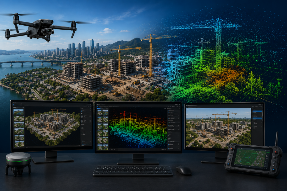
3D Gaussian Splatting, often shortened to 3DGS, is a modern 3D reconstruction and rendering technique designed to create highly realistic visual representations of real-world scenes. Instead of representing a surface only as a traditional triangular mesh, Gaussian Splatting uses many small 3D elements, called Gaussian splats, to reproduce the color, transparency, shape and visual appearance of a scene.
The result can look much more natural than a standard 3D mesh, especially when the goal is visual realism rather than engineering measurement. For example, vegetation, complex textures, reflective surfaces, facades, urban environments and irregular details can often appear more realistic in a Gaussian Splatting visualization than in a conventional mesh model.
For drone mapping, this is important because aerial imagery often captures large and complex scenes. A construction site, industrial facility, city block, historical building or landscape can be difficult to represent perfectly with a traditional mesh. Gaussian Splatting gives professionals another way to transform drone images into a realistic 3D environment.
How DJI Terra Uses 3D Gaussian Splatting
DJI officially presents DJI Terra as 3D modeling software equipped with next-generation reconstruction technologies, including 3D Gaussian Splatting. According to DJI, Terra supports accurate and efficient 2D and 3D reconstruction from visible-light imagery and can also process data collected by DJI LiDAR systems.
In practical terms, this means DJI Terra is trying to combine several reconstruction methods inside one platform:
- 2D reconstruction for orthomosaics and mapping outputs
- Traditional 3D reconstruction for models and meshes
- LiDAR reconstruction for point clouds and terrain-related workflows
- 3D Gaussian Splatting for photorealistic visualization
This is important because different projects require different outputs. A surveyor may need an orthomosaic and DSM. A construction company may need a 3D model for progress reporting. An inspection team may need a point cloud. A real estate or digital twin project may need a photorealistic visual model. DJI Terra is increasingly positioned to support all these needs inside a single DJI-centered ecosystem.
Why 3D Gaussian Splatting Matters for Drone Professionals
The biggest advantage of 3D Gaussian Splatting is visual realism. Many traditional drone mapping outputs are technically useful but not always easy for non-technical clients to understand. A dense point cloud may contain valuable information, but it can look abstract. A mesh model may be measurable, but it can appear artificial or simplified. A Gaussian Splatting model can provide a more immersive and realistic visual experience.
This matters because many drone deliverables are now used not only by surveyors and engineers, but also by project managers, executives, public authorities, investors, construction teams, emergency planners and clients who may not be experts in geospatial data.
With 3D Gaussian Splatting, drone professionals can potentially deliver models that are easier to explore, easier to present and more visually impressive. This can improve communication and increase the perceived value of drone mapping services.
3DGS vs Traditional Photogrammetry
Traditional photogrammetry reconstructs geometry from overlapping images. It can generate point clouds, meshes, textures, orthomosaics and elevation models. This is still essential for many professional workflows because it supports measurable outputs and geospatial deliverables.
3D Gaussian Splatting is different. It is mainly focused on realistic scene representation and visual rendering. It can produce highly detailed and natural-looking results, but it should not automatically be considered a replacement for every photogrammetry workflow.
The key point is this: 3DGS is not necessarily replacing photogrammetry. It is expanding what drone 3D modeling can do.
| Technology | Main Strength | Best For | Main Limit |
|---|---|---|---|
| Traditional Photogrammetry | Geometry, measurements and standard mapping outputs | Surveying, orthomosaics, DSM, meshes, GIS/CAD workflows | Visual realism can be limited in complex scenes |
| LiDAR Point Clouds | Dense 3D data and terrain/structure capture | Forestry, corridors, utilities, terrain, infrastructure | Usually less intuitive for non-technical visualization |
| 3D Gaussian Splatting | Photorealistic visualization and immersive scene rendering | Digital twins, presentations, inspections, urban visualization | Not always ideal as a replacement for survey-grade deliverables |
Best Use Cases for 3D Gaussian Splatting in DJI Terra
1. Construction Progress Visualization
Construction companies can use drone data to monitor job sites over time. Traditional orthomosaics and 3D meshes are useful, but Gaussian Splatting can make progress visualization more realistic and easier to understand.
For example, a project manager may want to see the actual visual condition of a construction site, including equipment, building structures, terrain, temporary roads and surrounding context. A photorealistic 3DGS model can help stakeholders understand the site quickly, even if they are not trained in GIS or photogrammetry.
2. Digital Twins and Smart Cities
Digital twin projects require realistic and regularly updated representations of real-world assets. 3D Gaussian Splatting can support this by creating more immersive visual scenes from drone imagery.
Urban blocks, campuses, industrial zones, ports, bridges and public spaces can be captured by drone and reconstructed into visually rich 3D environments. This can help planners, engineers and decision-makers inspect and communicate complex spatial information.
3. Infrastructure Inspection
Inspection workflows can benefit from realistic 3D models because inspectors often need to understand spatial relationships and visual context. Bridges, towers, powerlines, industrial plants and large facilities can be difficult to interpret from flat images alone.
A 3DGS model can allow teams to explore the scene from different angles and better understand the inspected asset. This does not remove the need for detailed inspection images or measurements, but it can improve situational awareness.
4. Cultural Heritage Documentation
Historical buildings, monuments, archaeological sites and cultural landscapes can benefit from photorealistic reconstruction. In these cases, visual fidelity is often as important as geometric accuracy.
3D Gaussian Splatting can help create realistic digital records that are useful for documentation, education, tourism, preservation and virtual access. DJI Terra’s integration of 3DGS may make this type of workflow more accessible to drone operators using DJI equipment.
5. Real Estate and Tourism
Real estate, hospitality and tourism projects often need visually attractive 3D content. Traditional drone photos and videos are powerful, but interactive 3D environments can provide a different level of engagement.
Gaussian Splatting can be useful for presenting resorts, large properties, scenic areas, golf courses, commercial developments and landmark sites. The goal is not always measurement; sometimes the goal is visual communication.
6. Emergency Response and Public Safety
After a disaster, accident or emergency event, teams may need a realistic reconstruction of the affected area. 3DGS can help create an immersive visual record that supports situational awareness, training, documentation and communication.
For public safety users, realistic 3D visualization can make complex scenes easier to understand. However, critical decisions should still rely on validated geospatial data, inspection images and professional analysis.
Why DJI Terra Could Make 3DGS More Accessible
One of the main barriers to advanced 3D reconstruction technologies is workflow complexity. Many Gaussian Splatting tools require technical knowledge, command-line operations or custom pipelines. This can limit adoption among surveyors, drone service providers and enterprise users who need practical production workflows.
DJI Terra could make 3DGS more accessible by integrating it into a familiar drone mapping software environment. For users already working with DJI drones, this reduces the gap between data capture and advanced visualization.
This is where DJI’s ecosystem advantage becomes important. DJI controls a large part of the professional drone workflow: aircraft, payloads, RTK systems, flight planning, reconstruction software, model editing software and viewing tools. If these components work together smoothly, advanced 3D modeling can become easier for non-specialist teams to adopt.
Professional Benefits of 3DGS in DJI Terra
- More realistic 3D outputs: 3DGS can make reconstructed scenes look more natural and immersive.
- Better client communication: Non-technical users may understand realistic 3D scenes more easily than point clouds or meshes.
- Stronger visual deliverables: Drone service providers can offer more impressive presentation products.
- Useful for digital twins: 3DGS can support realistic site visualization and repeated documentation.
- Integrated workflow: DJI Terra can reduce the complexity of using 3DGS compared with separate experimental tools.
Current Limits of 3D Gaussian Splatting
Despite its potential, 3D Gaussian Splatting should not be treated as a perfect replacement for all drone mapping outputs. It is extremely promising for visualization, but professional users should understand its limits.
First, 3DGS is mainly a visual reconstruction technology. If your project requires survey-grade measurements, contour lines, CAD deliverables, precise terrain analysis or engineering design inputs, you may still need traditional photogrammetry outputs, LiDAR point clouds or validated GIS data.
Second, visualization quality depends heavily on image capture quality. Poor overlap, motion blur, incorrect exposure, weak flight planning or missing viewpoints can reduce the quality of the final model.
Third, not every client or software environment may be ready to use Gaussian Splatting outputs. While adoption is growing, traditional formats like GeoTIFF, LAS/LAZ, OBJ, mesh models and point clouds remain widely used in professional geospatial workflows.
Does 3DGS Replace Mesh Models?
No, not completely. Mesh models are still very important because they represent surfaces in a way that can be used across many 3D, CAD, GIS and simulation workflows. Meshes can be textured, measured, edited, exported and integrated into many professional platforms.
3D Gaussian Splatting is often better for visual realism, but mesh models may still be better for editing, measurement, simulation, 3D printing, CAD integration or structured 3D deliverables.
The best professional workflow may use both. For example, a surveyor or drone company might deliver an orthomosaic, DSM, point cloud and mesh for technical use, plus a 3DGS visualization for presentation and client communication.
DJI Terra, DJI Modify and DJI Reality: A Bigger Strategy
3DGS in DJI Terra becomes even more interesting when seen together with DJI Modify and DJI Reality. DJI Terra processes and reconstructs drone data. DJI Modify helps edit and repair 3D models and point clouds. DJI Reality supports visualization and review of 3D mapping outputs.
This suggests that DJI is not only adding one new feature. It is building a broader 3D mapping ecosystem. For professional users, this could mean a smoother workflow from data capture to reconstruction, cleanup and final visualization.
If DJI continues in this direction, the future of drone 3D modeling may become less fragmented. Instead of using many disconnected applications, DJI users may be able to manage more of the process inside a connected software environment.
Who Should Use 3D Gaussian Splatting in DJI Terra?
3DGS in DJI Terra is especially interesting for users who need realistic 3D visualization from drone imagery. It may be valuable for:
- Drone service providers offering premium 3D deliverables
- Construction companies documenting project progress
- Surveyors who want better visual presentations for clients
- Urban planners and smart city teams
- Infrastructure inspection companies
- Real estate and tourism professionals
- Cultural heritage and digital preservation teams
- Public safety and emergency response organizations
However, users who only need basic 2D mapping or strict survey deliverables may not need 3DGS for every project. It is most valuable when visual realism and communication are important parts of the deliverable.
How to Capture Better Drone Data for 3DGS
Good 3DGS results start in the field. Even the best reconstruction technology cannot fully compensate for poor data capture. For drone professionals, flight planning is still critical.
Recommended capture practices include:
- Use high image overlap to improve scene coverage
- Capture oblique images for vertical surfaces and facades
- Avoid strong motion blur by using appropriate shutter speed
- Maintain consistent exposure where possible
- Capture the subject from multiple angles
- Avoid missing areas in complex structures
- Use RTK or control workflows when geospatial accuracy is required
- Test a small project before using the workflow commercially
For the best results, drone operators should think about 3DGS before flying. A mission planned only for a flat orthomosaic may not provide enough visual coverage for a strong 3DGS model. Oblique imagery and multi-angle capture are often more important for realistic 3D reconstruction.
3D Gaussian Splatting in DJI Terra: Future or Hype?
3D Gaussian Splatting is not just hype, but it should be understood correctly. It is not the end of photogrammetry, and it is not a complete replacement for LiDAR, mesh models or survey-grade mapping outputs. Instead, it is a powerful new layer for photorealistic 3D visualization.
For drone professionals, this can be a real opportunity. Clients increasingly want deliverables that are not only accurate but also easy to understand. 3DGS can help bridge the gap between technical mapping and immersive visual communication.
DJI Terra’s integration of 3DGS is important because it brings this technology closer to everyday drone mapping users. Instead of remaining a niche tool for researchers or 3D specialists, Gaussian Splatting can become part of a more practical workflow for drone service providers and enterprise teams.
Final Verdict: Is 3DGS the Future of Drone 3D Modeling?
3D Gaussian Splatting is likely to become a major part of the future of drone 3D modeling, especially for visualization, digital twins, inspection, cultural heritage and client presentation. In DJI Terra, it gives drone professionals a new way to create realistic 3D scenes from aerial imagery.
However, the future is not 3DGS alone. Professional drone modeling will likely combine several technologies: photogrammetry for measurable outputs, LiDAR for dense spatial data, meshes for structured 3D models and Gaussian Splatting for photorealistic visualization.
For DJI users, the addition of 3DGS makes DJI Terra more attractive and more future-oriented. It shows that DJI is not only improving traditional mapping workflows, but also preparing for a new generation of immersive 3D deliverables.
Need help choosing the right DJI Terra license for 3D modeling? Contact our team for professional guidance. We can help you compare DJI Terra Standard, Flagship, Cluster, DJI Modify and related options based on your drone model, project type and required 3D outputs.
FAQ: 3D Gaussian Splatting in DJI Terra
What is 3D Gaussian Splatting in DJI Terra?
3D Gaussian Splatting in DJI Terra is a reconstruction and visualization technology that helps create realistic 3D scene representations from visible-light images. It is designed to improve visual realism compared with many traditional 3D outputs.
Is 3D Gaussian Splatting the same as photogrammetry?
No. Traditional photogrammetry focuses on reconstructing geometry and producing outputs such as point clouds, meshes, orthomosaics and elevation models. 3D Gaussian Splatting focuses more on realistic visual rendering of a scene.
Does 3DGS replace LiDAR?
No. LiDAR remains important for dense 3D data, terrain modeling, vegetation penetration and many professional surveying workflows. 3DGS is better understood as a visualization technology rather than a full LiDAR replacement.
Is 3D Gaussian Splatting useful for surveyors?
Yes, but mainly for visualization, presentation and communication. For survey-grade measurements and engineering deliverables, surveyors should still rely on validated photogrammetry, LiDAR and control workflows.
Which DJI Terra version supports Gaussian Splatting?
DJI’s store and reseller information indicate that Gaussian Splatting is associated with the Flagship-level feature set rather than the Standard version. Users should always confirm license details before purchasing because availability may vary by region and package.
What are the best use cases for 3DGS in drone mapping?
The best use cases include construction visualization, digital twins, cultural heritage, real estate, urban mapping, infrastructure inspection and any project where realistic 3D presentation is important.
Can I use 3DGS outputs for measurements?
3DGS should not be treated as the primary measurement deliverable unless the specific workflow and software tools support validated measurements. For professional measurements, use standard photogrammetry, LiDAR, point clouds, DSMs, orthomosaics and control-based workflows.
Is 3D Gaussian Splatting the future of drone 3D modeling?
It is likely to become an important part of the future, especially for realistic visualization. However, it will probably work alongside photogrammetry, LiDAR and mesh modeling rather than replacing them completely.