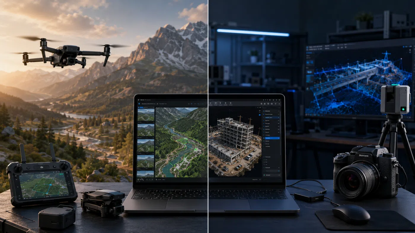
Choosing between DJI Terra and Agisoft Metashape is one of the most common decisions for drone mapping professionals, surveyors, construction companies, inspection teams and geospatial service providers. Both software solutions can transform drone data into valuable digital outputs, but they are not designed with exactly the same philosophy.
DJI Terra is strongly connected to the DJI Enterprise ecosystem. It is designed to work efficiently with DJI drones, DJI payloads and DJI LiDAR systems, offering a more integrated workflow from data acquisition to 2D maps, 3D models and point cloud outputs. Agisoft Metashape, on the other hand, is a highly flexible stand-alone photogrammetry platform used across many industries, including drone mapping, GIS, cultural heritage, engineering, research, mining and visual effects.
So, which one is better for drone mapping? The answer depends on your workflow. If you mainly use DJI Enterprise drones and want a streamlined DJI-centered solution, DJI Terra can be an excellent choice. If you need broader flexibility, support for many types of cameras and sensors, advanced photogrammetry control, automation and cross-platform use, Agisoft Metashape may be the stronger option.
In this guide, we compare DJI Terra vs Agisoft Metashape in a practical way, helping you understand which software is better for your drone mapping business, your technical requirements and your expected deliverables.
What Is DJI Terra?
DJI Terra is DJI’s professional software platform for drone mapping, 2D reconstruction, 3D reconstruction, LiDAR point cloud processing and advanced modeling workflows. It is designed to work closely with DJI Enterprise drones and DJI payloads, creating a unified workflow for aerial surveying, reconstruction and visualization.
DJI presents Terra as 3D modeling software equipped with next-generation reconstruction technologies, including 3D Gaussian Splatting. It supports 2D and 3D reconstruction from visible-light imagery and can process data collected by DJI LiDAR. This makes DJI Terra especially attractive for users already operating DJI drones and DJI sensors.
In 2026, DJI Terra is no longer only a simple mapping application. With versions such as DJI Terra V5.2.0 and the broader ecosystem including DJI Modify and DJI Reality, DJI is clearly building a more complete workflow for reconstruction, editing and visualization.
What Is Agisoft Metashape?
Agisoft Metashape is a professional photogrammetry software platform that processes digital images and generates 3D spatial data. It is widely used for drone mapping, GIS applications, cultural heritage documentation, indirect measurements, visual effects, archaeology, architecture, surveying, mining and scientific research.
Metashape Professional includes advanced features such as photogrammetric triangulation, dense point cloud generation and editing, DSM and DTM generation, orthomosaic production, georeferencing, support for ground control points, coordinate system management, multispectral and thermal imagery processing, LiDAR data support and automation options.
One of Metashape’s biggest strengths is flexibility. It is not limited to one drone brand or one hardware ecosystem. Users can process images from many different cameras, drones, terrestrial cameras, multispectral systems, fisheye cameras, spherical cameras and even scanned imagery, depending on the workflow and edition.
DJI Terra vs Agisoft Metashape: The Core Difference
The most important difference is philosophy.
DJI Terra is an ecosystem-driven solution. It works best when combined with DJI drones, DJI Enterprise payloads, DJI LiDAR systems and DJI’s broader software environment. Its value is speed, integration and workflow simplicity for DJI users.
Agisoft Metashape is a flexible photogrammetry engine. It is designed to process many types of image datasets and give users deeper control over photogrammetric workflows, coordinate systems, processing parameters and export options.
In simple terms: DJI Terra is often better for DJI-centered production workflows. Agisoft Metashape is often better for users who need flexibility, control and broader data compatibility.
Quick Comparison Table
| Category | DJI Terra | Agisoft Metashape |
|---|---|---|
| Main Strength | Integrated workflow with DJI drones and payloads | Flexible professional photogrammetry for many sensors and workflows |
| Best For | DJI Enterprise users, mapping, LiDAR, 3D visualization | Surveying, research, cultural heritage, GIS, custom photogrammetry |
| Drone Compatibility | Strongest with DJI ecosystem | Broad compatibility with many cameras and drones |
| 2D Mapping | Strong for DJI-based orthomosaic workflows | Strong and highly configurable |
| 3D Modeling | Strong, with modern visualization such as 3D Gaussian Splatting | Strong traditional photogrammetry, mesh, texture and model workflows |
| LiDAR | Good fit for DJI LiDAR payload workflows | Supports LiDAR data as part of broader processing workflows |
| Automation | More ecosystem-oriented | Strong automation potential with Python scripting |
| Operating System | Windows-focused | Available for Windows, macOS and Linux |
| Learning Curve | Easier for DJI users | More technical, but more flexible |
| Best Choice If… | You mainly use DJI Enterprise hardware and want a streamlined workflow | You need maximum flexibility, control and broad sensor support |
Which Software Is Easier to Use?
For many DJI drone users, DJI Terra is easier to start with. If your data comes from DJI Enterprise drones and payloads, the workflow can feel more direct. The software is designed around DJI’s ecosystem, which can reduce the number of technical decisions beginners need to make.
This is especially useful for companies that want to standardize internal workflows. A construction company, inspection team or public agency using DJI drones may prefer a software solution that feels closely connected to the hardware they already use.
Agisoft Metashape may have a steeper learning curve, but it provides more flexibility. Users can adjust many processing settings, manage complex coordinate systems, use different image sources, work with control points and automate workflows. For beginners, this can feel more technical. For advanced users, it is one of Metashape’s biggest advantages.
Which Software Is Better for 2D Mapping?
Both DJI Terra and Agisoft Metashape can be used for 2D mapping and orthomosaic generation.
DJI Terra is a strong choice when the imagery comes from DJI drones and the user wants a streamlined workflow. Recent versions also add practical geospatial features such as GeoTIFF COG output, which can improve usability in downstream GIS workflows.
Agisoft Metashape is also very strong for orthomosaic production. It gives users extensive control over alignment, optimization, DEM generation, orthorectification and export. For surveyors and GIS professionals who need to manage complex coordinate systems, vertical datums, GCPs or custom workflows, Metashape may provide more control.
For simple and efficient DJI-based mapping, DJI Terra can be easier. For complex or highly configurable 2D mapping workflows, Agisoft Metashape is often the more flexible option.
Which Software Is Better for 3D Modeling?
DJI Terra and Agisoft Metashape both support 3D reconstruction, but they approach the problem differently.
DJI Terra is increasingly focused on modern 3D visualization, including 3D Gaussian Splatting. This makes it interesting for users who need photorealistic visual models, construction visualization, digital twin-style outputs or immersive scene presentation.
Agisoft Metashape is very strong for traditional photogrammetric 3D modeling. It can generate dense point clouds, meshes and textured models, and it is widely used for cultural heritage, archaeology, engineering, scientific documentation and professional 3D reconstruction. It is also useful when the dataset comes from non-DJI cameras, terrestrial photography or mixed capture methods.
If your goal is realistic DJI-based 3D visualization, DJI Terra is becoming very attractive. If your goal is a flexible, deeply configurable photogrammetry workflow for many project types, Agisoft Metashape remains one of the strongest choices.
Which Software Is Better for LiDAR?
DJI Terra is particularly relevant for users working with DJI LiDAR payloads. Because Terra is designed around DJI hardware, the LiDAR workflow can be more direct for DJI users. This is useful for corridor mapping, forestry, infrastructure inspection, terrain modeling and other projects where LiDAR data plays a central role.
Agisoft Metashape also supports LiDAR data, but its strength is in integrating different types of spatial data into broader photogrammetry and reconstruction workflows. Users who work with many sensor types or who need mixed-source processing may prefer Metashape’s flexibility.
For DJI LiDAR users who want a more integrated workflow, DJI Terra is a natural choice. For users combining LiDAR with various cameras, non-DJI sensors or custom workflows, Agisoft Metashape may offer more flexibility.
Which Software Is Better for Surveying?
Surveying requires more than attractive 3D models. It requires accuracy, georeferencing, coordinate system control, quality checks and reliable exports.
DJI Terra can be very useful for DJI-based surveying workflows, especially when combined with RTK-enabled drones, DJI payloads and DJI D-RTK systems. It is practical for teams that want to capture and process data within a single ecosystem.
Agisoft Metashape is a strong option for surveyors who need more control over georeferencing, GCP workflows, coordinate systems, DEM/DTM generation, orthomosaic production and export formats. Its support for EPSG coordinate systems, geoid-based vertical datums and photogrammetric adjustment tools makes it attractive for technically demanding survey workflows.
For standard DJI mapping and efficient production, DJI Terra may be easier. For advanced survey control and custom geospatial workflows, Metashape often provides deeper flexibility.
Which Software Is Better for Automation?
Agisoft Metashape has a major advantage for automation because of its Python scripting capabilities. This is important for companies that process large numbers of projects, build custom pipelines, run batch jobs, integrate processing with internal systems or use network processing.
DJI Terra is improving as part of DJI’s broader software ecosystem, but it is generally more focused on guided workflows and integration with DJI hardware. For users who want software that feels more automatic and DJI-centered, this can be an advantage. For users who need custom scripts and advanced workflow automation, Metashape is typically stronger.
Which Software Is Better for Mixed Drone Fleets?
If your company uses only DJI drones, DJI Terra may be a very efficient choice. But if your company uses DJI drones, non-DJI drones, terrestrial cameras, spherical cameras, multispectral sensors or custom imaging systems, Agisoft Metashape is usually the safer long-term option.
This is one of the most important practical differences. DJI Terra is strongest when the workflow is centered on DJI hardware. Metashape is more hardware-independent and can be used across many types of capture systems.
Pros and Limits of DJI Terra
Main Pros of DJI Terra
- Strong integration with DJI Enterprise drones and payloads
- Efficient workflow for DJI users
- Good support for DJI LiDAR workflows
- Modern 3D reconstruction and visualization features
- 3D Gaussian Splatting support in the DJI Terra ecosystem
- Good choice for construction, surveying, inspection and enterprise DJI workflows
- Part of a broader ecosystem with DJI Modify and DJI Reality
Main Limits of DJI Terra
- Best value is inside the DJI ecosystem
- Less ideal for mixed non-DJI sensor workflows
- Licensing options can be confusing for new users
- May offer less flexibility for highly customized photogrammetry workflows
- Windows-focused compared with cross-platform alternatives
Pros and Limits of Agisoft Metashape
Main Pros of Agisoft Metashape
- Very flexible photogrammetry software
- Works with many cameras, drones and imaging workflows
- Strong control over processing parameters
- Professional tools for GCPs, DEM/DTM, orthomosaics and coordinate systems
- Python scripting for automation
- Available for Windows, macOS and Linux
- Widely used in surveying, cultural heritage, research, GIS and VFX
Main Limits of Agisoft Metashape
- Can have a steeper learning curve for beginners
- Less “one-click” for DJI-specific workflows compared with DJI Terra
- Users may need more technical knowledge for advanced settings
- Model editing and visualization may require additional tools depending on the project
Best Use Cases for DJI Terra
DJI Terra is usually the better choice when your workflow is strongly based on DJI Enterprise hardware and you want a streamlined software environment.
- DJI Enterprise drone mapping
- DJI LiDAR point cloud processing
- Construction site monitoring with DJI drones
- Infrastructure inspection using DJI payloads
- 3D visualization and 3D Gaussian Splatting workflows
- Teams that want a simpler DJI-centered process
- Organizations already using DJI Terra, DJI Modify and DJI Reality
Best Use Cases for Agisoft Metashape
Agisoft Metashape is usually the better choice when flexibility, control and broad compatibility are more important than staying inside a single hardware ecosystem.
- Surveying with advanced GCP and coordinate workflows
- Processing images from many different camera systems
- Mixed drone fleet operations
- Cultural heritage and archaeology
- Scientific research and custom photogrammetry
- Automation through Python scripting
- Large projects requiring configurable processing pipelines
- Users who need Windows, macOS or Linux support
Which One Should You Choose?
Choose DJI Terra if your workflow is mainly based on DJI Enterprise drones and DJI payloads, and if you want a streamlined mapping and reconstruction solution that works naturally within the DJI ecosystem. DJI Terra is especially attractive for users who need DJI LiDAR processing, efficient 2D and 3D reconstruction, modern visualization and integration with tools such as DJI Modify and DJI Reality.
Choose Agisoft Metashape if you need more flexibility, broader camera compatibility, advanced photogrammetry controls, cross-platform availability, Python automation or complex geospatial workflows. Metashape is particularly strong for technical users who want deeper control over the reconstruction process and who may work with many different types of datasets.
In short: DJI Terra is often better for DJI-centered efficiency. Agisoft Metashape is often better for technical flexibility.
Final Verdict: DJI Terra vs Agisoft Metashape
There is no single winner for every drone mapping professional. DJI Terra and Agisoft Metashape are both powerful, but they serve different needs.
DJI Terra is the better choice for users who want a modern, integrated DJI mapping ecosystem. It is practical, efficient and increasingly powerful for DJI Enterprise drone workflows, LiDAR processing and visual 3D reconstruction.
Agisoft Metashape is the better choice for users who need an independent, flexible and highly configurable photogrammetry platform. It is especially strong for advanced surveying, mixed sensors, research, cultural heritage, automation and complex reconstruction workflows.
The best software is the one that matches your real production environment. If you work almost entirely with DJI drones and need a fast, integrated workflow, DJI Terra may be the smarter choice. If you need maximum photogrammetry flexibility and professional control, Agisoft Metashape may be the better long-term investment.
Need help choosing between DJI Terra and Agisoft Metashape? Contact our team for professional guidance. We can help you compare licenses, workflows, drone compatibility, LiDAR requirements, 3D reconstruction options and the best software solution for your mapping business.
FAQ: DJI Terra vs Agisoft Metashape
Is DJI Terra better than Agisoft Metashape?
DJI Terra can be better for users who mainly work with DJI Enterprise drones and DJI payloads. Agisoft Metashape can be better for users who need broader flexibility, advanced photogrammetry control, cross-platform support and automation.
Is Agisoft Metashape better for professional surveying?
Agisoft Metashape is very strong for professional surveying because it offers advanced georeferencing, coordinate system control, GCP workflows, DEM/DTM generation and configurable processing. DJI Terra can also be effective for DJI-based surveying workflows.
Which software is easier for beginners?
DJI Terra is often easier for beginners who already use DJI drones because the workflow is more integrated. Agisoft Metashape may require more learning, but it provides more control and flexibility.
Can DJI Terra process LiDAR data?
Yes, DJI Terra can process data collected by DJI LiDAR systems, making it a strong option for DJI LiDAR users working in surveying, forestry, infrastructure and terrain mapping.
Can Agisoft Metashape process LiDAR data?
Yes, Agisoft Metashape supports LiDAR data and can integrate it into broader photogrammetry and spatial data workflows, depending on the project requirements.
Which software is better for 3D models?
DJI Terra is strong for DJI-based 3D modeling and modern visualization such as 3D Gaussian Splatting. Agisoft Metashape is strong for traditional photogrammetric 3D models, textured meshes and flexible reconstruction workflows.
Which software is better for mixed drone fleets?
Agisoft Metashape is usually better for mixed drone fleets because it is not tied to a single hardware ecosystem and can process images from many types of cameras and drones.
Does Agisoft Metashape support automation?
Yes, Agisoft Metashape Professional supports Python scripting, which makes it useful for automation, batch processing and custom photogrammetry workflows.
Which software should a DJI Enterprise user choose?
A DJI Enterprise user should seriously consider DJI Terra because of its integration with DJI drones and payloads. However, if the user needs advanced custom processing or non-DJI compatibility, Agisoft Metashape should also be evaluated.
Can both software solutions be used together?
Yes. Some professionals may use DJI Terra for DJI-specific workflows and Agisoft Metashape for more complex, flexible or custom photogrammetry projects. The best setup depends on the company’s deliverables and data sources.