DJI Terra has become one of the most important software platforms for professionals using DJI drones in surveying, mapping, construction, infrastructure inspection, mining, forestry and 3D reconstruction. As DJI continues to improve Terra with 2D mapping, 3D reconstruction, LiDAR point cloud processing, 3D Gaussian Splatting and integration with DJI Modify and DJI Reality, many professionals are asking a very practical question: can DJI Terra replace traditional surveying software?
The short answer is: DJI Terra can replace some parts of a traditional surveying workflow, but it does not replace every professional surveying tool. It is extremely useful for turning drone data into orthomosaics, point clouds, 3D models, DEMs and visual reconstruction outputs. However, surveyors may still need CAD, GIS, coordinate transformation tools, field data management software, legal survey platforms, advanced point cloud classification tools or specialized engineering design software depending on the project.
In other words, DJI Terra is not simply a “surveying software replacement.” It is better understood as a powerful drone data processing and reconstruction platform that can become a central part of a modern surveying workflow.
In this article, we explain what DJI Terra can replace, what it cannot replace, and how surveyors should use it alongside traditional surveying software for professional results.
What Is DJI Terra?
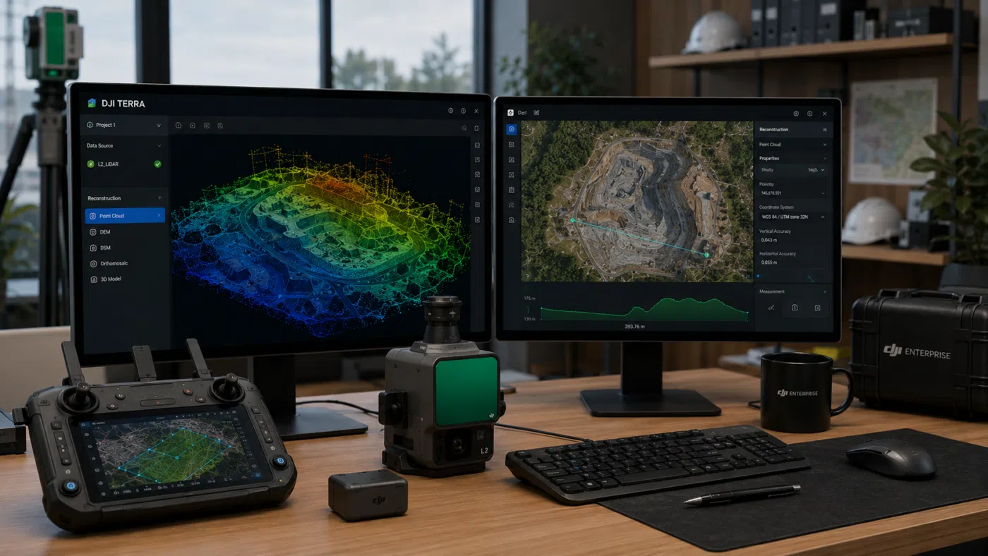
DJI Terra is DJI’s professional software for 2D reconstruction, 3D reconstruction, LiDAR point cloud processing and advanced drone mapping workflows. It is designed to work closely with DJI Enterprise drones, DJI payloads and DJI LiDAR systems, providing an integrated workflow from data acquisition to processing and output generation.
DJI describes Terra as 3D modeling software equipped with next-generation reconstruction technologies, including 3D Gaussian Splatting. It supports 2D and 3D reconstruction from visible-light imagery and can process data collected by DJI LiDAR. When combined with DJI drones, Terra provides a unified hardware and software workflow for aerial surveying and mapping.
For surveyors, this makes DJI Terra valuable because it helps transform field-captured drone data into digital deliverables such as orthomosaics, point clouds, 3D models, DEMs and visualization outputs. These deliverables can then be used in GIS, CAD, reporting, inspection, terrain analysis or client presentations.
What Is Traditional Surveying Software?
Traditional surveying software is a broad category. It can include CAD software, GIS platforms, field-to-finish tools, total station and GNSS data management systems, point cloud analysis software, coordinate transformation tools, terrain modeling applications and engineering design platforms.
Examples of traditional surveying software workflows may include:
- Managing GNSS and total station measurements
- Processing control networks
- Creating CAD drawings
- Producing legal survey plans
- Generating contour maps and terrain models
- Designing roads, drainage, earthworks or infrastructure
- Performing coordinate transformations
- Classifying and editing large point clouds
- Publishing geospatial data in GIS platforms
These workflows often go beyond drone mapping. They include legal, engineering, geodetic and design requirements that a drone reconstruction tool may not fully cover.
The Key Difference: Reconstruction vs Surveying Production
The most important concept is the difference between reconstruction software and full surveying production software.
DJI Terra is primarily a reconstruction and drone data processing platform. It processes images, LiDAR data and mapping projects to create outputs that can be used in surveying and engineering workflows.
Traditional surveying software often handles the next stage: detailed drafting, CAD layers, alignments, surfaces, feature coding, legal deliverables, design integration, coordinate transformations and project documentation.
This means DJI Terra can be the source of valuable survey data, but it may not be the final environment where every professional surveying deliverable is completed.
What DJI Terra Can Replace
1. Basic Drone Mapping Processing Tools
For users working with DJI Enterprise drones, DJI Terra can replace many basic drone mapping applications. It can process drone imagery into 2D maps and 3D models, making it suitable for site documentation, construction monitoring, land mapping and visual reconstruction.
If your previous workflow used a simple mapping tool only to create orthomosaics and basic 3D models, DJI Terra may be able to replace it completely, especially when your data comes from DJI drones.
2. Some Photogrammetry Workflows
DJI Terra can handle many photogrammetry tasks, including 2D and 3D reconstruction from visible-light imagery. For DJI-based projects, this can reduce the need for separate photogrammetry software, especially when the goal is efficient output generation rather than highly customized processing.
However, users with mixed camera systems, advanced scripting needs or complex photogrammetry requirements may still prefer specialized photogrammetry platforms.
3. DJI LiDAR Point Cloud Processing
DJI Terra is particularly relevant for DJI LiDAR workflows. It can process data from DJI LiDAR payloads and generate point cloud outputs for professional applications. DJI support documentation also describes LiDAR workflows involving ground point classification and DEM generation.
For users working with Zenmuse L1, Zenmuse L2 or other supported DJI LiDAR datasets, DJI Terra can become the main point cloud reconstruction tool before data is exported into CAD, GIS or point cloud analysis software.
4. Some DEM and Terrain Output Generation
DJI Terra can support terrain-related outputs such as DEM generation from LiDAR point cloud projects. In LiDAR workflows, ground point classification is required when generating DEM outputs. This makes DJI Terra useful for topographic mapping, terrain documentation and early-stage surface generation.
For many projects, Terra can create the base terrain dataset. However, final engineering surfaces, design grading and advanced earthworks analysis may still require CAD or civil engineering software.
5. Visual 3D Communication Tools
With 3D reconstruction and 3D Gaussian Splatting, DJI Terra can replace some basic 3D visualization workflows. Surveyors and drone service providers can use Terra to create more realistic visual outputs for clients, construction teams or project stakeholders.
This is especially useful when the goal is communication rather than legal survey production. A realistic 3D model can help non-technical users understand site conditions more easily than a point cloud or CAD drawing.
What DJI Terra Cannot Fully Replace
1. CAD Drafting and Final Survey Plans
DJI Terra can generate data that supports surveying, but it is not a full CAD drafting platform. Surveyors who need to produce final drawings, legal plans, boundaries, parcels, annotations, layers, profiles, sections and engineering layouts will still need CAD or survey drafting software.
For example, a drone orthomosaic or point cloud may be used as a reference, but final deliverables often require linework, dimensions, labels, title blocks and compliance with local standards.
2. GIS Database Management
DJI Terra can export geospatial outputs, but it is not a complete GIS database management platform. If a project requires spatial databases, attribute tables, web GIS publishing, layer management, topology rules, geoprocessing or multi-user data management, a dedicated GIS platform is still necessary.
DJI Terra can produce valuable inputs for GIS. It does not replace GIS itself.
3. Legal Boundary Surveying
Drone mapping cannot replace the professional responsibility of a licensed surveyor. Boundary determination, cadastral surveys, legal land records, property disputes and official survey plans require professional judgment, legal evidence and compliance with local regulations.
DJI Terra can help document land and create visual/geospatial outputs, but it does not replace legal surveying procedures.
4. GNSS and Total Station Network Adjustment
Traditional surveying often involves precise GNSS observations, total station measurements, traverse adjustment and control network management. DJI Terra is not designed to replace dedicated survey adjustment software for these tasks.
Drone data should be connected to reliable ground control when accuracy is required. The control network itself may still need to be established, checked and adjusted using traditional survey methods and software.
5. Advanced Civil Engineering Design
DJI Terra can support terrain model generation, but it does not replace civil design software for roads, drainage, corridors, grading, subdivisions, utility networks or infrastructure design.
For example, Terra can help produce a point cloud or DEM of an existing site. Engineers may then use that data inside civil engineering platforms to design proposed surfaces, alignments, profiles and construction plans.
6. Advanced Point Cloud Editing and Classification
DJI Terra can process and generate point cloud outputs, especially from DJI LiDAR data. However, some projects require advanced point cloud classification, manual editing, feature extraction, cross-section generation, corridor analysis or integration with specialized LiDAR software.
In these cases, DJI Terra may be the first processing stage, but additional point cloud software may still be needed.
Where DJI Terra Fits in a Professional Surveying Workflow
The best way to understand DJI Terra is to place it inside the full surveying workflow.
| Workflow Stage | Can DJI Terra Help? | Do You Still Need Traditional Software? |
|---|---|---|
| Drone data capture planning | Yes, especially in DJI workflows | Sometimes, for broader mission planning or compliance |
| Image reconstruction | Yes | Only if advanced/custom photogrammetry is required |
| LiDAR point cloud reconstruction | Yes, for DJI LiDAR workflows | Sometimes, for advanced classification and analysis |
| Orthomosaic generation | Yes | GIS may be needed for final map integration |
| DEM generation | Yes, depending on workflow | CAD/GIS may be needed for final terrain modeling |
| Contour and surface analysis | Partially | Yes, for detailed engineering and survey deliverables |
| CAD drafting | No, not as a full replacement | Yes |
| Legal survey plans | No | Yes |
| GIS database management | No, not as a full replacement | Yes |
| Client visualization | Yes | Sometimes, depending on delivery format |
Best Use Cases Where DJI Terra Can Reduce Traditional Software Dependence
1. Construction Progress Mapping
Construction teams often need regular site documentation rather than complex legal survey plans. DJI Terra can create orthomosaics, 3D models and point clouds that help track progress, document earthworks and communicate site conditions.
In this use case, DJI Terra can reduce dependence on traditional software for basic visual reporting. However, CAD or BIM tools may still be needed for design comparison and engineering documentation.
2. Quarry and Mining Site Monitoring
Quarries and mining sites often require regular terrain updates, stockpile documentation and site visualization. DJI Terra can help create drone-based datasets that support operational monitoring.
For more advanced volume calculations, compliance reporting or mine planning, specialized mining or CAD software may still be required.
3. Forestry and Vegetation Mapping
LiDAR workflows are especially useful in forestry because they can support terrain extraction beneath vegetation. DJI Terra can process DJI LiDAR data and help generate point clouds and DEM-related outputs.
For advanced forestry metrics, biomass modeling or scientific classification, additional software may be needed.
4. Infrastructure Inspection
DJI Terra can support 3D reconstruction and LiDAR point cloud workflows for bridges, roads, powerlines, towers, solar farms and industrial sites. These outputs can help inspection teams understand asset conditions and spatial context.
However, inspection management systems, CAD tools or specialized analysis software may still be needed for defect tracking, engineering review and reporting.
5. Topographic Data Collection
For many topographic drone surveys, DJI Terra can generate the base orthomosaic, point cloud or DEM. This can reduce the amount of manual field measurement required, especially over large or difficult terrain.
Still, professional topographic deliverables often require quality control, feature extraction, CAD drafting and survey validation outside Terra.
Accuracy: What Professionals Must Understand
One of the most important questions is accuracy. DJI Terra can produce accurate outputs when data is captured correctly, but software alone does not guarantee survey-grade accuracy.
Accuracy depends on many factors:
- Drone and sensor quality
- Flight altitude and overlap
- RTK or PPK quality
- Ground control points
- Checkpoints
- Coordinate system settings
- Camera calibration
- LiDAR calibration and trajectory quality
- Processing parameters
- Quality control procedures
A visually impressive 3D model is not automatically a survey-grade deliverable. Professional surveyors should validate results with independent checkpoints and compare outputs against project specifications.
DJI Terra vs Traditional Surveying Software: Not a Replacement, but a Workflow Upgrade
The most accurate answer is that DJI Terra is not a full replacement for traditional surveying software. Instead, it is a workflow upgrade for drone-based data acquisition and reconstruction.
Traditional surveying software remains essential for many professional tasks, especially CAD drafting, GIS management, legal survey documentation, engineering design, coordinate network adjustment and advanced deliverable production.
DJI Terra is strongest at the stage where drone data becomes useful digital information. It can generate orthomosaics, 3D reconstructions, LiDAR point clouds, DEM-related outputs and visual models. These outputs can then be used in traditional software for final survey production.
Recommended Professional Workflow
For many surveyors, the best workflow is not “DJI Terra instead of traditional software.” It is “DJI Terra plus traditional software.”
- Use GNSS, total station or control points to establish reliable survey control.
- Capture drone imagery or LiDAR data with DJI Enterprise hardware.
- Process images or LiDAR data in DJI Terra.
- Export orthomosaics, DEMs, point clouds or 3D models.
- Validate outputs with checkpoints and quality control procedures.
- Import the data into CAD, GIS or survey software.
- Create final survey deliverables, drawings, reports or engineering outputs.
This workflow uses DJI Terra where it is strongest, while still relying on traditional survey tools where they remain necessary.
When DJI Terra May Be Enough
DJI Terra may be enough when the project requires visual documentation, basic mapping, preliminary terrain outputs or internal reporting rather than formal survey deliverables.
Examples include:
- Construction progress images and 3D views
- Internal site monitoring
- Basic orthomosaic generation
- Drone-based visual inspection
- Preliminary terrain review
- Client presentations
- Digital twin visualization
In these cases, DJI Terra may provide most of what the user needs.
When Traditional Surveying Software Is Still Required
Traditional surveying software is still required when the project involves legal, engineering or high-precision deliverables.
Examples include:
- Boundary surveys
- Legal land plans
- Subdivision design
- Road and infrastructure design
- CAD drawings with layers, linework and annotations
- Complex coordinate transformations
- Control network adjustment
- Detailed feature extraction
- Advanced point cloud classification
- Engineering-grade terrain modeling
In these workflows, DJI Terra can provide source data, but traditional software remains necessary for final production.
Pros and Limits of DJI Terra for Surveyors
Main Pros
- Strong integration with DJI Enterprise drones and payloads
- Efficient 2D and 3D reconstruction workflows
- Useful for DJI LiDAR point cloud processing
- Can generate outputs for CAD, GIS and reporting workflows
- Supports modern visualization, including 3D Gaussian Splatting
- Can reduce office processing time for drone projects
- Useful for construction, mining, forestry, inspection and mapping
Main Limits
- Does not fully replace CAD drafting software
- Does not replace legal surveying judgment or procedures
- Does not replace full GIS database management
- May require additional software for advanced point cloud editing
- Survey-grade accuracy still requires field control and validation
- Best value is inside the DJI ecosystem
Final Verdict: Can DJI Terra Replace Traditional Surveying Software?
DJI Terra can replace some drone mapping and reconstruction tools, especially for DJI-based workflows. It can generate orthomosaics, 3D models, LiDAR point clouds, DEM-related outputs and visual reconstructions that are highly valuable for modern surveying projects.
However, DJI Terra should not be seen as a complete replacement for traditional surveying software. It does not fully replace CAD, GIS, legal surveying software, field-to-finish systems, network adjustment tools or advanced engineering design platforms.
The best way to use DJI Terra is as a powerful reconstruction and data preparation tool inside a professional surveying workflow. It helps convert drone data into accurate and useful digital outputs, which can then be validated, refined and delivered using traditional survey, CAD and GIS platforms.
For professionals, the conclusion is clear: DJI Terra may not replace traditional surveying software entirely, but it can significantly improve how surveyors collect, process and deliver drone-based geospatial data.
Need help choosing the right DJI Terra license for surveying? Contact our team for professional guidance. We can help you compare DJI Terra Standard, Flagship, Agriculture, Cluster and DJI Modify options based on your drone model, LiDAR workflow, project size and required survey deliverables.
FAQ: Can DJI Terra Replace Traditional Surveying Software?
Can DJI Terra replace CAD software?
No. DJI Terra can generate useful mapping and reconstruction outputs, but it does not fully replace CAD software for drafting, linework, annotations, engineering drawings or legal survey plans.
Can DJI Terra replace GIS software?
No. DJI Terra can export geospatial data, but it does not replace a full GIS platform for database management, spatial analysis, web publishing, attribute management and multi-layer geospatial workflows.
Can DJI Terra be used for professional surveying?
Yes. DJI Terra can be used in professional surveying workflows, especially for drone-based mapping, LiDAR point cloud reconstruction, orthomosaic generation, DEM outputs and 3D reconstruction. However, final accuracy must be validated.
Is DJI Terra accurate enough for survey work?
DJI Terra can produce accurate results when the data is captured correctly using proper flight planning, RTK/PPK, ground control points, checkpoints and suitable processing settings. Accuracy should always be validated against project requirements.
Can DJI Terra process LiDAR data?
Yes. DJI Terra can process data collected by DJI LiDAR systems and supports LiDAR point cloud reconstruction workflows, including DEM generation workflows that require ground point classification.
Can DJI Terra generate DEMs?
Yes, DJI Terra can generate DEM outputs in supported LiDAR workflows. DJI documentation notes that ground point classification is required when generating DEM results from LiDAR point cloud missions.
Is DJI Terra enough for construction site monitoring?
For many construction monitoring workflows, DJI Terra may be enough to generate orthomosaics, 3D models and visual progress documentation. For design comparison, CAD drawings or BIM integration, additional software may still be required.
Is DJI Terra enough for legal boundary surveys?
No. DJI Terra can support mapping and documentation, but legal boundary surveys require licensed surveyor judgment, field evidence, control networks and compliance with local regulations.
What software should be used with DJI Terra?
DJI Terra is often used alongside CAD, GIS, point cloud analysis, civil engineering, survey drafting or reporting software, depending on the final deliverable.
Should surveyors buy DJI Terra?
Surveyors using DJI Enterprise drones or DJI LiDAR payloads should strongly consider DJI Terra because it can streamline drone data processing. However, they should evaluate it as part of a complete workflow rather than as a total replacement for all surveying software.