Drone modeling is entering a new phase. For years, professional drone mapping has mainly focused on orthomosaics, point clouds, textured meshes, digital surface models and LiDAR datasets. These outputs remain essential for surveying, engineering, construction, inspection and GIS workflows. However, a new reconstruction technology is changing how professionals think about 3D visualization: 3D Gaussian Splatting.
With DJI Terra now integrating 3D Gaussian Splatting into its reconstruction ecosystem, drone operators can move beyond traditional 3D meshes and generate more realistic visual representations of real-world scenes. This does not mean that Gaussian Splatting replaces photogrammetry, LiDAR or survey-grade deliverables. Instead, it adds a powerful new layer to drone modeling: photorealistic 3D visualization.
For DJI Enterprise users, this matters because DJI Terra is becoming more than a mapping application. It is evolving into a complete reconstruction environment that includes 2D mapping, 3D reconstruction, DJI LiDAR processing, Gaussian Splatting, DJI Modify and DJI Reality. The result is a more complete workflow from drone flight to model generation, editing and visualization.
In this article, we explain what 3D Gaussian Splatting is, why it matters inside DJI Terra, how it could change drone modeling and which professionals can benefit most from this technology.
What Is 3D Gaussian Splatting?
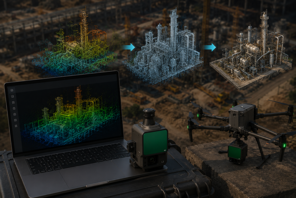
3D Gaussian Splatting, often called 3DGS, is a modern 3D reconstruction and rendering technique designed to create highly realistic visual representations of real-world scenes. Instead of displaying a scene only as a traditional mesh made of polygons, Gaussian Splatting represents the scene using many small 3D elements called Gaussian splats.
Each splat carries information about position, color, transparency and shape. When rendered together, these splats can create a very realistic 3D scene that looks natural from different viewpoints. The result can be especially impressive for complex surfaces, vegetation, urban scenes, industrial facilities and objects with rich visual detail.
For drone modeling, this is important because aerial imagery often captures large and visually complex environments. Traditional photogrammetry can generate useful meshes and textures, but the final model may sometimes look artificial, simplified or incomplete in challenging areas. Gaussian Splatting can make the visual reconstruction feel more realistic and immersive.
How DJI Terra Uses 3D Gaussian Splatting
DJI describes DJI Terra as 3D modeling software equipped with next-generation reconstruction technologies, including 3D Gaussian Splatting. The software supports 2D and 3D reconstruction from visible-light imagery and can also process data collected by DJI LiDAR systems.
This means DJI Terra is increasingly positioned as a multi-output reconstruction platform. A professional user may process drone data and generate different deliverables depending on the project:
- Orthomosaic maps for 2D mapping
- Point clouds for spatial analysis
- 3D meshes for traditional modeling
- LiDAR point clouds for terrain and infrastructure workflows
- 3D Gaussian Splatting scenes for realistic visualization
The key point is that Gaussian Splatting does not replace the entire mapping workflow. It expands it. DJI Terra users can still create technical outputs, while also generating more visually realistic 3D scenes for communication, inspection, presentation and digital twin workflows.
Why Gaussian Splatting Could Change Drone Modeling
1. More Realistic 3D Scenes
The most obvious advantage of 3D Gaussian Splatting is realism. Drone models often need to communicate real-world conditions to people who are not photogrammetry experts. A construction manager, property investor, public official or infrastructure stakeholder may not understand a point cloud, but they can immediately understand a realistic 3D scene.
Gaussian Splatting can make reconstructed drone scenes look closer to reality. This can improve the perceived quality of drone deliverables and make 3D models more useful in presentations, reviews and project communication.
2. Better Visualization of Complex Environments
Some environments are difficult for traditional visible-light mesh reconstruction. Vegetation, steel structures, substations, construction sites and industrial facilities can create visual complexity. DJI has specifically highlighted Gaussian Splatting fusion reconstruction as useful in challenging scenarios such as complex steel structures, substations and dense vegetation.
For drone professionals, this is important because many high-value projects are complex. Industrial inspection, infrastructure documentation and construction monitoring often involve irregular geometry, reflective materials, shadows, vegetation and dense structural detail. Gaussian Splatting can help make these scenes easier to visualize.
3. Stronger Client Communication
Many drone mapping deliverables are technically powerful but difficult for clients to interpret. A point cloud is useful, but it may look abstract. A mesh model is useful, but it may contain artifacts. A realistic 3DGS scene can be more intuitive for non-technical audiences.
This can be a commercial advantage for drone service providers. Instead of delivering only maps and technical files, they can offer an immersive visual reconstruction that helps clients understand the site immediately.
4. New Opportunities for Digital Twins
Digital twin workflows require clear and updated representations of real-world assets. Gaussian Splatting can make these digital representations more realistic and easier to explore visually.
For construction sites, industrial plants, campuses, real estate developments and infrastructure assets, this can support more engaging digital twin presentations. A 3DGS scene may not replace engineering data, but it can become a valuable visual layer inside a broader digital twin workflow.
5. A Bridge Between Mapping and Visualization
Traditional drone mapping often serves technical users such as surveyors, engineers and GIS specialists. Gaussian Splatting can help drone modeling reach a broader audience: marketing teams, real estate developers, investors, public agencies, architects, safety managers and executives.
This is why the technology could change the drone modeling market. It makes 3D reconstruction more accessible and visually compelling, which can increase demand for drone-based 3D deliverables.
3D Gaussian Splatting vs Traditional Drone Modeling
To understand the value of 3DGS, it is important to compare it with traditional drone modeling methods.
| Method | Main Strength | Best Use Cases | Main Limitation |
|---|---|---|---|
| Orthomosaic Mapping | Accurate 2D site overview | Surveying, construction monitoring, GIS, land documentation | Does not provide immersive 3D visualization |
| Traditional 3D Mesh | Structured 3D surface model | 3D modeling, inspection, CAD/GIS workflows, documentation | Can show artifacts or reduced realism in complex scenes |
| LiDAR Point Cloud | Dense 3D spatial data | Terrain, forestry, corridors, utilities, infrastructure | Less intuitive for non-technical visualization |
| 3D Gaussian Splatting | Photorealistic visual reconstruction | Digital twins, presentations, real estate, inspection, visual communication | Not always a replacement for survey-grade measurement deliverables |
Best Use Cases for 3D Gaussian Splatting in DJI Terra
1. Construction Progress Visualization
Construction companies can use 3DGS to create realistic visual updates of job sites. Compared with a traditional 3D mesh, a Gaussian Splatting scene can feel more natural and easier to interpret. Project managers can review the site visually, compare progress and communicate updates to stakeholders.
This is especially useful for large construction sites where weekly or monthly drone flights are already part of the workflow.
2. Real Estate and Property Presentation
Real estate developers and property owners can use 3DGS to create immersive site presentations. A realistic reconstruction of a property, resort, commercial area or development site can help buyers and investors understand the space remotely.
This is not just a technical output. It can become a marketing asset.
3. Infrastructure Inspection
Infrastructure assets such as bridges, towers, roads, industrial plants, substations and utility corridors can be difficult to communicate through flat images alone. Gaussian Splatting can provide a more realistic spatial context for inspection teams and stakeholders.
It should not replace detailed inspection imagery or engineering analysis, but it can improve visual understanding of the asset.
4. Industrial Facilities and Substations
Industrial facilities often contain complex structures, pipes, steel frameworks and equipment. DJI has highlighted complex steel structures and substations as scenarios where Gaussian Splatting fusion reconstruction can provide superior visual results compared with conventional visible-light mesh reconstruction.
This makes 3DGS especially interesting for inspection, safety review, asset documentation and digital twin applications.
5. Cultural Heritage and Tourism
Historical buildings, archaeological sites and cultural landscapes can benefit from realistic visual reconstruction. 3DGS can help create immersive digital records that are useful for preservation, education and virtual access.
For tourism and cultural heritage, visual realism is often just as important as geometric precision.
6. Public Safety and Emergency Response
After a disaster, accident or emergency event, a realistic 3D reconstruction can help teams understand the scene. 3DGS can provide visual context for planning, reporting and training.
For mission-critical decisions, it should be combined with validated geospatial data and professional analysis.
Why DJI Terra Makes 3DGS More Practical
One reason 3D Gaussian Splatting is becoming more important is that it is moving from experimental workflows into professional software. Many early Gaussian Splatting workflows required technical knowledge, command-line tools or custom pipelines. That created a barrier for drone operators and mapping companies.
DJI Terra can make the technology more accessible by integrating it into a drone mapping environment already used by DJI Enterprise professionals. This matters because adoption depends on workflow simplicity.
If a drone operator can capture data with a DJI drone, process it in DJI Terra and visualize or refine the output through DJI’s broader software ecosystem, 3DGS becomes much easier to offer as a real service.
Where 3DGS Still Has Limits
Despite its potential, 3D Gaussian Splatting should be used with realistic expectations. It is powerful for visualization, but it should not automatically replace photogrammetry, LiDAR or survey-grade workflows.
Important limits include:
- It is mainly a visual reconstruction technology
- It may not be the best format for CAD or engineering design
- It should not replace validated survey outputs when measurements matter
- Output quality depends heavily on image capture quality
- Some clients may still require traditional formats such as LAS, OBJ, GeoTIFF or CAD files
- Large scenes may require strong hardware and careful workflow planning
For this reason, professionals should treat 3DGS as a complementary deliverable. It can be extremely valuable for visualization, but technical outputs remain necessary for many professional projects.
How to Capture Better Drone Data for 3DGS
The quality of a 3DGS model starts in the field. Poor image capture will reduce the quality of the final reconstruction, even with advanced software.
Recommended capture practices include:
- Capture the subject from multiple angles
- Use high overlap between images
- Include oblique images for facades and vertical structures
- Avoid motion blur with correct shutter speed
- Maintain consistent exposure where possible
- Avoid missing viewpoints around complex objects
- Use RTK or ground control when geospatial accuracy is required
- Test the workflow on a small project before offering it commercially
A flight planned only for a flat orthomosaic may not provide enough coverage for a strong 3DGS result. For realistic drone modeling, data capture must be planned for 3D from the beginning.
Which Professionals Benefit Most?
3D Gaussian Splatting in DJI Terra can be valuable for many professional users, especially those who need realistic visual deliverables in addition to technical mapping outputs.
- Drone service providers offering premium 3D modeling services
- Construction companies documenting progress
- Real estate developers and marketing teams
- Industrial inspection teams
- Infrastructure operators
- Surveyors who want better visual communication tools
- Public agencies and emergency response teams
- Cultural heritage and tourism professionals
- Digital twin teams
Is 3D Gaussian Splatting the Future of Drone Modeling?
3D Gaussian Splatting is likely to become an important part of the future of drone modeling, but not the only future. Professional drone workflows will continue to use multiple technologies depending on the required deliverable.
Photogrammetry will remain essential for orthomosaics, meshes and measurable outputs. LiDAR will remain essential for dense 3D spatial data, vegetation, terrain and infrastructure. Point clouds and CAD/GIS outputs will remain necessary for technical workflows. Gaussian Splatting will add a more realistic visual layer.
The future is not one format replacing all others. The future is a richer set of outputs from the same drone data.
DJI Terra, DJI Modify and DJI Reality: A Bigger Ecosystem
The arrival of 3DGS in DJI Terra is even more interesting when seen together with DJI Modify and DJI Reality. DJI Terra handles reconstruction. DJI Modify supports 3D model editing and cleanup. DJI Reality supports viewing and visualization workflows.
This suggests that DJI is building a broader 3D mapping ecosystem, not just adding a single feature. For DJI Enterprise users, this could reduce the need to combine many disconnected tools for processing, editing and viewing 3D data.
For drone modeling businesses, that ecosystem could make advanced 3D deliverables easier to produce and sell.
Final Verdict
3D Gaussian Splatting in DJI Terra could change drone modeling because it makes realistic 3D visualization more accessible to professional drone users. It gives mapping companies, surveyors, construction teams, real estate developers and infrastructure operators a new way to present and understand drone-captured environments.
However, it should not be treated as a replacement for every traditional output. Orthomosaics, point clouds, LiDAR datasets, meshes, DEMs and CAD/GIS deliverables remain essential. The real value of 3DGS is that it adds a more immersive and client-friendly visual layer to the drone mapping workflow.
For DJI Enterprise users, this is a major opportunity. DJI Terra is becoming a platform where technical mapping and visual storytelling can meet. That is why 3D Gaussian Splatting could be one of the most important changes in drone 3D modeling.
Need help choosing the right DJI Terra license for 3D Gaussian Splatting? Contact our team for professional guidance. We can help you compare DJI Terra Standard, Flagship, Cluster, DJI Modify and related options based on your drone model, project type and required 3D outputs.
FAQ: 3D Gaussian Splatting in DJI Terra
What is 3D Gaussian Splatting in DJI Terra?
3D Gaussian Splatting is a reconstruction and visualization technology that helps create realistic 3D scenes from images. In DJI Terra, it is part of the software’s next-generation 3D reconstruction workflow.
Why is 3D Gaussian Splatting important for drone modeling?
It can create more realistic and immersive visual reconstructions than many traditional 3D outputs, making drone models easier to present and understand for non-technical users.
Does 3DGS replace photogrammetry?
No. 3DGS does not replace photogrammetry. It complements it by adding a strong visual reconstruction layer, while photogrammetry remains essential for maps, meshes, point clouds and measurable outputs.
Does 3DGS replace LiDAR?
No. LiDAR remains important for terrain, vegetation, corridor mapping, infrastructure and dense spatial data. Gaussian Splatting is mainly valuable for realistic visualization.
What are the best use cases for 3DGS in DJI Terra?
The best use cases include construction visualization, real estate presentation, infrastructure inspection, industrial facilities, cultural heritage, digital twins and client-facing 3D deliverables.
Is 3DGS useful for surveyors?
Yes, but mainly for visualization and communication. For survey-grade measurements, surveyors should still rely on validated photogrammetry, LiDAR, control points and traditional geospatial deliverables.
Do I need special drone data for 3DGS?
You need high-quality image capture with strong overlap and multiple viewing angles. Oblique images are especially important for buildings, facades and complex 3D structures.
Which DJI Terra license supports 3D Gaussian Splatting?
License availability can vary by region and package. DJI and reseller information generally associate Gaussian Splatting with higher-tier DJI Terra options rather than basic mapping workflows, so users should confirm current license details before purchasing.
Can 3DGS be used for real estate marketing?
Yes. Real estate is one of the most promising use cases because realistic 3D scenes can make properties, developments and large sites easier to present remotely.
Is 3D Gaussian Splatting just a trend?
No. It is a serious reconstruction and visualization technology. However, it should be used as part of a broader drone mapping workflow rather than as a replacement for all traditional outputs.