

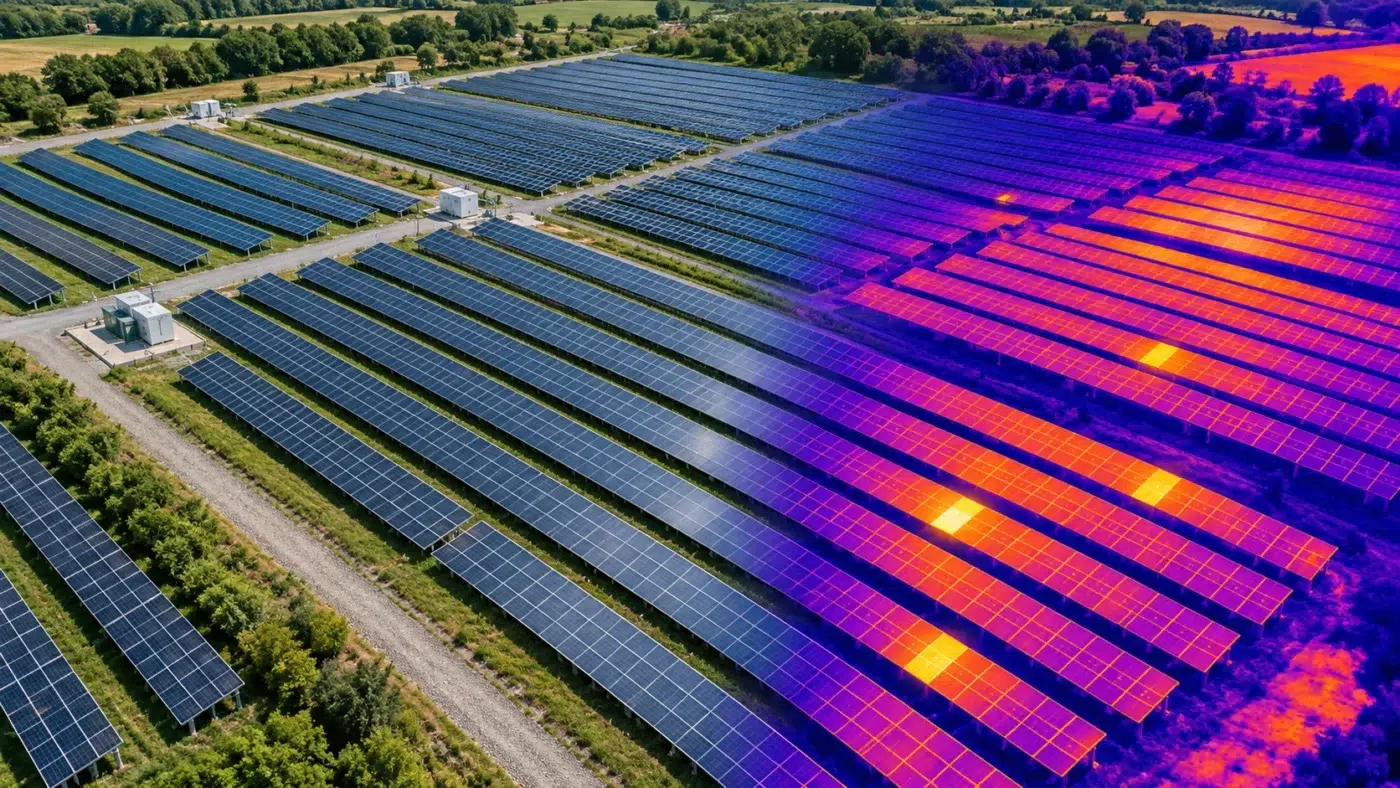
THERMAL MAPS & INSPECTION WORKFLOWS
Put thermal observations into a map the inspection team can use
DJI Terra thermal mapping brings paired visible-light and thermal imagery into a site-wide inspection view. It can help teams locate observations and review temperature information across an asset, rather than relying only on isolated photographs.
This guide explains the reconstruction workflow announced by DJI in July 2026, capture preparation, temperature review, solar inspection use and reporting. It separates the software’s mapping capabilities from the evidence needed for a reliable technical conclusion.
Can DJI Terra create thermal maps?
Yes. DJI’s July 2026 update announcement describes Thermal Infrared 2D Reconstruction. Visible-light photographs provide aerial triangulation, with paired thermal imagery used to create a thermal map containing temperature information.
This changes how inspection observations can be organized: one map gives site context, while source images retain the detail of each observation. Keep both so the reviewer can move from the overview to the supporting capture.
A thermal map and a fault diagnosis answer different questions
A map can show where an unusual temperature pattern was observed. Identifying the cause and deciding maintenance action requires asset context, suitable acquisition conditions and qualified interpretation. A bright color alone is not proof of a defect.
Terra, individual-image analysis and asset management
| Task | Role in the workflow | What to preserve |
|---|---|---|
| Site-wide thermal reconstruction | Terra combines eligible paired imagery into a mapped result. | Original captures, positioning information and project settings. |
| Detailed source-image review | A compatible thermal-image analysis tool supports examination of individual images. | Original radiometric files and analysis parameters. |
| Asset diagnosis and maintenance | Inspection specialists relate observations to equipment and operating evidence. | Asset identifiers, field verification and work-order decisions. |
| Recurring performance tracking | An asset-management process organizes accepted observations across dates. | Comparable capture conditions, identifiers and revision history. |
Do not assume that generating a map automatically delivers every inspection function needed by the client. Agree whether the output is an overview, a temperature review, an anomaly register or a maintenance-ready asset report.
For individual-image workflows, DJI provides its Thermal Analysis Tool through relevant official product downloads. Check the supported camera and file version rather than assuming every thermal image is interchangeable.
Check your drone, camera, release and license first
The update announcement lists Mavic 3T, Matrice 3TD, Matrice 4T, Matrice 4TD, Zenmuse H20N, H20T and H30T capture systems. This list describes the announced workflow; review the installed release and current compatibility documentation before planning a project.
Keep a preflight compatibility record: aircraft and payload, firmware, Pilot 2 release, Terra release, image format and software entitlement. A thermal camera on an aircraft does not automatically establish compatibility with every Terra reconstruction function.
Use our supported drones and sensors guide, versions and release notes page and license guide together. Confirm thermal reconstruction entitlement for the proposed product before purchase; do not infer it from the edition name alone.
Before a large capture, test a small representative paired dataset on the intended workstation. Confirm that it reconstructs, retains the required temperature information and supports the handover the client expects.
Capture paired RGB and thermal data deliberately
DJI describes paired visible-light and infrared capture in Pilot 2, with flight planning based on the thermal camera’s resolution. Because the documented triangulation uses visible-light photos, DJI advises against low-light capture for this reconstruction workflow.
Use the platform-specific instructions for lens selection, image pairing and capture settings. Preserve original files and metadata rather than screenshots, resaved JPEGs or a colorized video export.
- Agree the target detail: define the size of the feature that the inspection must resolve.
- Review visibility: structures, panel angles and occlusion can prevent complete asset coverage.
- Check representative captures: confirm sharp RGB data, usable thermal data and complete pairing before repeating the mission.
- Record conditions: log timing, relevant weather and asset operating conditions for the review.
- Preserve traceability: keep image names, timestamps and aircraft records with the project.
The current DJI guide gives scene-dependent overlap and distance recommendations. Treat these as capture guidance, not a universal inspection specification or an accuracy guarantee. Plan within the aircraft operating requirements and applicable flight permissions.
DJI’s Mavic 3T solar inspection article also describes platform-specific heading and gimbal planning. Match the capture plan to the required analysis workflow.
A practical DJI Terra thermal reconstruction workflow
- Archive the original paired image folders and acquisition notes. Work from a copy.
- Create the applicable thermal reconstruction project in the supported Terra release and import the eligible data.
- Review positioning information, image pairing and the visible-light alignment before accepting the reconstruction.
- Configure the thermal calculation settings using the documented camera and material parameters. Keep a record of the selected values.
- Process a representative area, inspect coverage and compare the mapped result with source observations.
- Complete the remaining area only after the test meets the inspection requirements. Save the project and its supporting records.
The appropriate workstation depends on dataset size and the reconstruction setup. Check our Terra system requirements guide before the first production project. For general processing failures, use the reconstruction troubleshooting guide.
A completed processing task is only one milestone. Inspect whether the map contains all required assets and whether the available detail supports the intended temperature review.
Read temperature information, not just palette colors
DJI documents point, line and area temperature review, palette selection and temperature display ranges in the reconstructed map. It also describes emissivity and environmental parameters, with XLSX and PDF report outputs.
Treat display choices and measurement assumptions separately. A palette changes the presentation; it does not change the physical asset. A narrow display range can make small differences appear dramatic, while a broad range can conceal a subtle pattern.
Keep the review reproducible
- Record the palette and display range used for a comparison.
- Retain the analysis parameter values and explain their basis.
- Name each observation with a stable asset or location identifier.
- Compare the mapped observation with the original thermal and visible-light images.
- Distinguish an estimated surface temperature from the temperature of an internal component.
Do not compare colors from different scales
Two assets shown in the same orange color may have different temperatures if their displays use different ranges. Compare the underlying values under a documented method, rather than matching colors between screenshots.
Use thermal maps for solar inspection without overstating the result
A solar-farm map is useful for finding the correct row, associating observations with modules and planning follow-up work. A practical report needs enough location detail for a technician to identify the same asset on the ground.
Agree the inspection method with the responsible specialist before capture. Record relevant irradiance, cloud changes, wind, shadows, viewing geometry and operating state so the specialist can decide whether observations are comparable and interpretable.
A simple observation record
| Field | Suggested content |
|---|---|
| Location | Site, block, row and module identifier where available. |
| Capture evidence | Date, time, original thermal image and matching RGB image. |
| Mapped observation | Point or area selected, values reviewed and analysis parameters. |
| Context | Visible damage, shading, soiling, operating information and relevant conditions. |
| Interpretation | Reviewer’s assessment and any need for additional investigation. |
| Follow-up | Responsible team, verification action and resolution status. |
For example, a warmer region may justify a closer inspection. Do not label it as a specific electrical failure based solely on the mosaic. Link observations to the diagnostic evidence and agreed acceptance criteria.
When comparing inspection dates, account for changed conditions and display settings. A difference in appearance can reflect a different capture situation rather than deterioration.
Deliver a thermal inspection package the recipient can reopen
Deliver the agreed outputs, report and supporting evidence together. A PDF is useful for communication, but it does not substitute for the original data where detailed reanalysis is required.
- Native Terra project and required supporting files.
- Original paired RGB and thermal captures.
- Reports and the agreed map outputs, tested in the receiving workflow.
- Asset identifiers and the method used to associate observations with them.
- Capture conditions, processing release and analysis parameters.
- Coverage gaps, unresolved observations and inspection limitations.
- Revision identifier and reviewer details.
Confirm thermal output behavior for your installed release. Do not assume a colorized map exported for another application retains radiometric values or all Terra measurement functions.
Our Terra to QGIS guide covers ordinary GeoTIFF and point cloud handovers. Validate a thermal handover separately against its temperature-data requirements.
DJI Terra thermal mapping FAQ
Can I reconstruct a thermal map from thermal images alone?
The DJI workflow discussed here uses visible-light imagery for aerial triangulation and matched thermal imagery for the map. Preserve the paired capture data and follow the requirements of the installed release.
Can I use ordinary screenshots of a thermal camera view?
Screenshots can illustrate an observation, but they do not substitute for the eligible original capture files and temperature information required for the reconstruction and analysis workflow.
Does the brightest area prove there is a fault?
No. Review the measured information, display range, source images, asset context and acquisition conditions. Diagnosis requires the applicable inspection method and supporting evidence.
Will a thermal map provide survey-grade geometry automatically?
Evaluate geometric performance against the project specification using appropriate checks. Temperature-analysis capability is not a guarantee of survey accuracy.
Can I schedule repeat inspections and compare the maps?
Yes, as a project workflow. Keep asset identifiers and acquisition methods consistent, record conditions, and explain differences in processing or analysis parameters before interpreting change.
Check your thermal processing setup before scaling the capture
Tell us the aircraft and payload, Terra release and required deliverables. We can help verify the software and licensing requirements for the proposed reconstruction workflow.
Official documentation
- DJI thermal reconstruction announcement and capture guidance
- Official DJI Terra thermal reconstruction tutorial
- DJI and Raptor Maps solar capture planning
- Official thermal analysis software downloads
- DJI Terra release documentation
Independent guide by Drone Emotions. Documentation reviewed on 9 October 2026. Consult the documentation for the installed software and capture-system releases.


