DJI Terra continues to evolve from a drone mapping application into a more complete reconstruction platform for surveyors, engineers, construction companies, inspection teams and enterprise drone operators. For professionals who rely on drone data to produce orthomosaics, 3D models, point clouds, terrain outputs and inspection-ready deliverables, every improvement in reconstruction technology can have a direct impact on productivity, accuracy and final project quality.
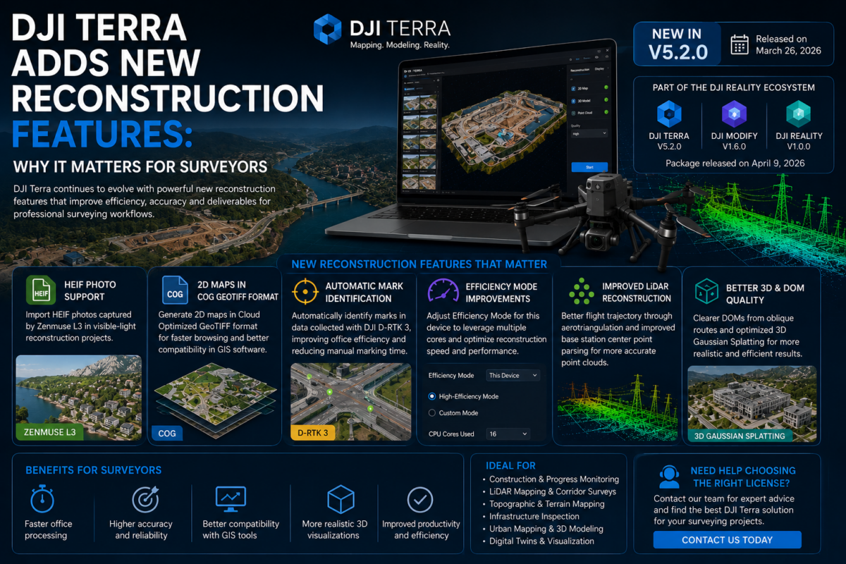
In 2026, DJI Terra is no longer just a simple tool for turning drone images into maps. It is becoming part of a broader DJI reality capture ecosystem that includes 2D mapping, 3D reconstruction, LiDAR processing, 3D Gaussian Splatting, DJI Modify and DJI Reality. DJI’s official download page lists DJI Terra V5.2.0 as released on March 26, 2026, and also lists a package including DJI Terra V5.2.0, DJI Modify V1.6.0 and DJI Reality V1.0.0, released on April 9, 2026.
For surveyors, these developments matter because reconstruction software is not just a technical detail. It determines how efficiently field data becomes usable information. Better reconstruction features can mean faster office processing, cleaner outputs, improved compatibility with GIS tools, better LiDAR point clouds and more realistic 3D visualizations.
In this article, we explain why DJI Terra’s new reconstruction features are important for surveyors and how they can affect professional drone mapping workflows.
Why Reconstruction Features Matter in Surveying
Surveying is based on reliable measurement, repeatable workflows and deliverables that can be used for real decisions. A drone flight is only the first step. The real value is created when the captured data is processed into accurate and understandable outputs.
For drone surveyors, reconstruction software typically supports outputs such as:
- Orthomosaics
- Digital surface models
- Digital terrain models
- 3D meshes
- Dense point clouds
- LiDAR point clouds
- Contour lines
- GIS-ready raster files
- Visual 3D models for reporting and inspection
When reconstruction features improve, the benefits can be significant. Surveyors may spend less time correcting data, exporting files, checking outputs or converting formats. Clients may receive clearer maps, better models and more usable geospatial deliverables.
This is why DJI Terra’s newer reconstruction features are important. They are not only visual upgrades. They can influence the full professional workflow from data capture to final delivery.
DJI Terra as a Reconstruction Platform
DJI Terra is DJI’s professional mapping and reconstruction software, designed to help users transform drone data into digital outputs for mapping, modeling and analysis. It is especially valuable for users already working inside the DJI Enterprise ecosystem, because it connects DJI drones, DJI payloads and DJI processing software in a more integrated workflow.
For surveyors, this integration is important. Many surveying teams use DJI Enterprise drones because they are efficient, widely available and compatible with professional mapping payloads. A software platform designed around that same ecosystem can reduce workflow friction and make project processing more predictable.
The latest DJI Terra updates show that DJI is investing in several reconstruction areas that matter to surveyors: 2D mapping, 3D reconstruction, LiDAR processing, automatic mark identification, GIS output compatibility and advanced visualization technologies.
Key Reconstruction Improvements Surveyors Should Watch
1. Better 2D Map Reconstruction
For many surveyors, the most important deliverable is still the orthomosaic. A high-quality 2D map can be used for site documentation, measurements, progress tracking, land planning, construction monitoring and GIS analysis.
DJI Terra’s recent improvements include support for generating 2D maps in GeoTIFF COG format. COG stands for Cloud Optimized GeoTIFF, a format designed to make large geospatial raster files easier to browse and use in downstream GIS environments.
This is highly relevant for surveyors because drone orthomosaics can become very large. A construction site, quarry, road corridor or agricultural area can generate heavy raster files that need to be opened, shared, archived or integrated into GIS platforms. COG output can make these files more practical for modern geospatial workflows.
For surveying companies, this means DJI Terra outputs can become easier to use beyond the software itself. Instead of treating the orthomosaic as a closed deliverable, teams can integrate it more smoothly into GIS, cloud mapping or client review workflows.
2. Improved LiDAR Point Cloud Reconstruction
LiDAR is becoming increasingly important in professional surveying. Compared with traditional photogrammetry, LiDAR can be more effective in certain environments, especially where vegetation, terrain complexity or structure geometry makes image-based reconstruction more difficult.
DJI Terra V5.2.0 includes optimizations for LiDAR point cloud reconstruction results, including improvements related to flight trajectory through aerotriangulation and base station center point parsing. For surveyors, these improvements matter because point cloud quality is closely connected to trajectory accuracy, positioning reliability and correct georeferencing.
A better LiDAR reconstruction workflow can help surveyors produce cleaner point clouds, reduce manual correction work and increase confidence in outputs. This is especially valuable for projects such as:
- Road and corridor mapping
- Powerline and utility surveys
- Forestry and vegetation mapping
- Quarries and mining sites
- Complex terrain modeling
- Infrastructure inspection
For companies using DJI LiDAR payloads, improvements inside DJI Terra can directly affect turnaround time and deliverable quality.
3. 3D Gaussian Splatting for More Realistic Reconstruction
One of the most interesting trends in DJI Terra is the introduction and optimization of 3D Gaussian Splatting, often referred to as 3DGS. This technology is becoming important for photorealistic scene reconstruction and visual 3D representation.
For traditional survey deliverables, a realistic 3D visualization is not always required. However, more clients now expect outputs that are not only measurable but also easy to understand. A highly realistic 3D scene can help communicate complex sites more effectively than a flat map or technical point cloud alone.
For surveyors, 3D Gaussian Splatting can be useful in areas such as:
- Digital twin visualization
- Infrastructure documentation
- Urban planning
- Construction progress reporting
- Cultural heritage documentation
- Inspection and stakeholder communication
DJI Terra V5.2.0 includes optimizations for 3DGS in visible-light reconstruction tasks, improving reconstruction results in Extra High quality mode and improving efficiency in High quality mode. This suggests that DJI is treating 3DGS not as a secondary experiment, but as an important part of its reconstruction roadmap.
4. Automatic Mark Identification with DJI D-RTK 3
Ground control and checkpoint workflows are critical for surveyors. However, manual mark identification can be time-consuming, especially when processing large projects or repeated missions.
DJI Terra V5.2.0 adds support for automatic mark identification for data collected with DJI D-RTK 3. DJI states that this can improve office processing efficiency and reduce manual marking time.
This is one of the most practical improvements for surveyors. Reducing manual marking time can help teams process more projects in less time. It can also improve consistency between operators, especially in companies where multiple technicians handle data processing.
For survey businesses, time saved in the office can be just as important as time saved in the field. Faster processing means faster delivery, better margins and the ability to manage more projects with the same team.
5. Better Reconstruction from Oblique Flight Routes
Oblique imagery is important for 3D reconstruction because it captures building facades, vertical structures and side details that nadir images cannot fully document. However, oblique datasets can be more complex to process, especially when users also need clean 2D deliverables.
DJI Terra V5.2.0 includes optimization for the quality of 2D reconstructed digital orthophoto maps from oblique flight route data. DJI describes the resulting imagery as clearer and more natural.
For surveyors, this can be useful in urban projects, infrastructure sites, building documentation and construction monitoring. It means that data captured for 3D purposes can also produce better 2D outputs, improving the overall value of a single flight mission.
Why These Features Matter for Surveying Workflows
The value of these reconstruction features becomes clearer when we look at the full workflow of a surveying project.
A typical drone surveying workflow includes:
- Mission planning
- Drone data capture
- GNSS or RTK/PPK data management
- Image or LiDAR import
- Ground control or checkpoint management
- 2D or 3D reconstruction
- Quality control
- Export to GIS, CAD or client-ready formats
- Reporting and delivery
DJI Terra’s reconstruction improvements affect several of these steps. HEIF support can simplify data import from supported DJI payloads. Automatic mark identification can reduce office work. LiDAR improvements can help with point cloud quality. COG output can improve GIS integration. 3DGS can make final visualization more powerful.
In other words, the improvements are not isolated. They can make the entire production chain more efficient.
Impact on Accuracy and Quality Control
Surveyors do not choose software only because it creates attractive outputs. Accuracy, repeatability and quality control are central to the profession.
DJI Terra’s reconstruction improvements can support quality in different ways. Better trajectory handling can help LiDAR reconstruction. More accurate base station center point parsing can improve reliability in georeferenced projects. Automatic mark identification can reduce manual work and help standardize processing. Improved contour interval handling, including fixes related to feet as a measurement unit, can also matter for users working in imperial-unit markets.
Of course, software alone does not guarantee survey-grade results. Accuracy also depends on flight planning, camera calibration, image overlap, RTK or PPK quality, ground control points, coordinate system settings, sensor quality and operator expertise.
However, stronger reconstruction tools can make it easier for surveyors to achieve consistent results when the field data has been captured correctly.
Impact on Deliverables
For surveyors, reconstruction features matter because they affect what can be delivered to clients. A better reconstruction workflow can improve both technical outputs and visual communication.
| Deliverable | How DJI Terra Reconstruction Features Help | Why It Matters for Surveyors |
|---|---|---|
| Orthomosaic | Improved 2D reconstruction and COG GeoTIFF output | Better GIS usability and easier sharing of large raster maps |
| LiDAR Point Cloud | Trajectory and base station parsing improvements | More reliable point cloud reconstruction and georeferencing |
| 3D Model | Improved visible-light reconstruction and 3DGS optimization | More realistic site visualization and better communication |
| Control Point Workflow | Automatic mark identification with DJI D-RTK 3 | Less manual processing time and improved office efficiency |
| Oblique Data Outputs | Clearer DOM results from oblique flight routes | Better use of complex datasets for both 2D and 3D deliverables |
| Contour Lines | Fixes related to contour intervals when using feet | Improved reliability for terrain outputs in imperial-unit workflows |
Best Use Cases for Surveyors
1. Construction Site Surveying
Construction sites benefit from frequent drone mapping. DJI Terra can help surveyors create orthomosaics, 3D models and visual progress documentation. Improved reconstruction features can make repeated site documentation faster and more consistent.
2. Road and Corridor Mapping
Corridor projects often involve long datasets, challenging alignment and large deliverables. LiDAR improvements, better trajectory handling and COG GeoTIFF export can be useful for these workflows.
3. Quarry and Mining Surveys
Quarries and mines require regular monitoring, terrain documentation and volume-related analysis. Better reconstruction efficiency and cleaner outputs can help teams deliver faster updates to clients or internal departments.
4. Urban Mapping
Urban environments are complex because they include buildings, vertical surfaces, roads, vegetation and infrastructure. Oblique imagery and 3D reconstruction improvements can help surveyors generate richer site documentation.
5. Infrastructure Inspection
Bridges, towers, industrial plants and utility corridors benefit from detailed digital documentation. DJI Terra’s 3D and LiDAR reconstruction improvements can support more complete inspection workflows.
6. Digital Twin Projects
More clients are asking for digital twins or realistic 3D site representations. 3D Gaussian Splatting can help surveyors offer more visually impressive deliverables, especially when the goal is communication, inspection or immersive visualization.
Should Surveyors Use DJI Terra as Their Main Reconstruction Tool?
DJI Terra can be a strong main reconstruction tool for surveyors who already work with DJI Enterprise drones and DJI payloads. Its biggest advantage is ecosystem integration. If your drone, sensor and processing software are designed to work together, the workflow can become more efficient and easier to standardize.
However, surveyors should still evaluate their specific requirements. If your work involves many non-DJI sensors, highly customized coordinate workflows, advanced photogrammetry scripting or mixed hardware fleets, you may need to compare DJI Terra with other professional mapping software before choosing it as your only processing platform.
For DJI-based surveying businesses, DJI Terra is becoming increasingly compelling. Its reconstruction features are improving in areas that directly matter to professional users: speed, output compatibility, LiDAR quality, automation and advanced 3D visualization.
Practical Advice Before Updating or Buying
Before adopting the latest DJI Terra version, surveyors should review their current workflow and test the software on sample datasets. This is especially important for companies working on active production projects or standardized deliverables.
Recommended steps include:
- Test DJI Terra on a representative project before changing your full workflow
- Check compatibility with your drone, payload and license type
- Verify coordinate system settings and output requirements
- Compare COG GeoTIFF outputs with your GIS software
- Review LiDAR point cloud quality before client delivery
- Validate accuracy with checkpoints where required
- Back up important projects before upgrading software
Professional survey workflows should always include quality control. New reconstruction features can improve efficiency, but final deliverables should still be checked against project requirements.
Final Verdict: Why It Matters for Surveyors
DJI Terra’s new reconstruction features matter because they address real production needs: faster processing, better 2D outputs, improved LiDAR reconstruction, automatic mark identification, better use of oblique data and more advanced 3D visualization.
For surveyors, this means DJI Terra is becoming more than a simple drone mapping tool. It is becoming a more complete reality capture and reconstruction platform inside the DJI Enterprise ecosystem.
If your surveying business already uses DJI drones and DJI payloads, DJI Terra’s reconstruction improvements can help reduce workflow complexity and improve deliverable quality. If your work depends on accurate mapping, LiDAR point clouds, 3D site models and GIS-ready outputs, these updates are worth serious attention.
Need help choosing the right DJI Terra license for surveying? Contact our team for professional guidance. We can help you compare DJI Terra Standard, Flagship, Agriculture, Cluster and DJI Modify options based on your drone model, sensor, project size and required deliverables.
FAQ: DJI Terra Reconstruction Features for Surveyors
Why are DJI Terra reconstruction features important for surveyors?
They affect how drone data is transformed into usable deliverables such as orthomosaics, point clouds, 3D models, terrain outputs and GIS-ready files. Better reconstruction features can improve efficiency, output quality and workflow consistency.
Does DJI Terra support LiDAR reconstruction?
Yes, DJI Terra supports LiDAR point cloud processing for compatible DJI workflows. Recent updates include improvements related to LiDAR point cloud reconstruction, flight trajectory optimization and base station center point parsing.
What is 3D Gaussian Splatting in DJI Terra?
3D Gaussian Splatting is an advanced reconstruction and visualization technology that can create realistic 3D scene representations. It is useful for visual inspection, digital twins, infrastructure documentation and immersive 3D visualization.
Why is COG GeoTIFF useful for surveyors?
COG GeoTIFF, or Cloud Optimized GeoTIFF, is useful because it makes large raster maps easier to browse and use in GIS or cloud-based workflows. This is especially valuable for large orthomosaics.
Does DJI Terra help with ground control workflows?
DJI Terra V5.2.0 adds automatic mark identification for data collected with DJI D-RTK 3, which can reduce manual marking time and improve office processing efficiency.
Is DJI Terra suitable for professional surveying?
DJI Terra can be suitable for professional surveying, especially when used with DJI Enterprise drones and compatible payloads. However, surveyors should always validate accuracy with appropriate quality control procedures.
Can DJI Terra replace other photogrammetry software?
It depends on the workflow. For DJI-based mapping and reconstruction, DJI Terra can be a strong choice. For highly customized workflows, non-DJI sensors or advanced scripting needs, surveyors should compare it with other professional software.
Should surveyors update to DJI Terra 5.2.0?
Surveyors should consider updating if they use DJI D-RTK 3, DJI LiDAR workflows, COG GeoTIFF outputs, oblique flight data, 3D Gaussian Splatting or compatible DJI Enterprise payloads. Production teams should test the update before using it on critical projects.