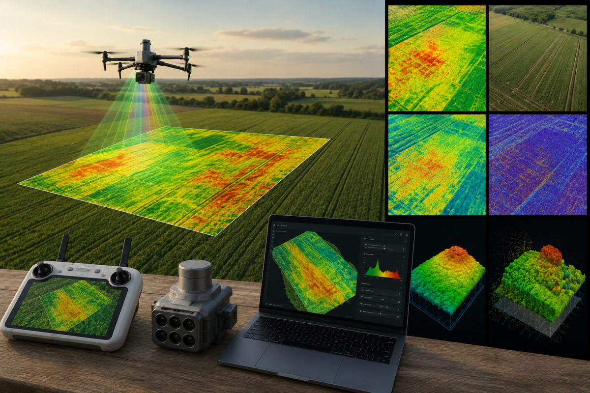
DJI Terra is not only a drone mapping and 3D reconstruction platform for surveying, construction and infrastructure. It can also play an important role in precision agriculture, especially when used with multispectral drones such as the DJI Mavic 3 Multispectral or Phantom 4 Multispectral. For farmers, agronomists, cooperatives and agricultural drone service providers, DJI Terra can help transform aerial multispectral data into vegetation index maps, reflectance maps and useful insights for crop monitoring.
In modern agriculture, visual inspection from the ground is no longer enough. Crops can show stress before it becomes visible to the human eye. Water problems, nutrient deficiencies, disease pressure, poor emergence, irrigation issues and field variability can all affect productivity. Multispectral drone mapping helps detect these patterns earlier and more systematically.
DJI Terra supports multispectral reconstruction using data from DJI Mavic 3 Multispectral and Phantom 4 Multispectral. According to DJI Store, it can generate vegetation index maps such as NDVI and NDRE, support radiometric correction and create reflectance maps for remote sensing research. This makes DJI Terra a practical software option for agricultural mapping and crop health analysis.
In this guide, we explain how DJI Terra can be used for agriculture, what NDVI and NDRE maps mean, how multispectral data works, which crop monitoring workflows are most useful and what professionals should know before using drone maps for farming decisions.
What Is DJI Terra for Agriculture?
DJI Terra is DJI’s professional software platform for drone mapping, 2D reconstruction, 3D reconstruction, LiDAR processing and multispectral workflows. In agriculture, its role is to process drone imagery and generate maps that help users understand crop conditions, field variability and vegetation health.
When used with compatible multispectral drones, DJI Terra can process data from multiple spectral bands. Instead of relying only on standard RGB photos, multispectral imaging captures information from specific wavelengths, including visible and near-infrared bands. This information can be used to calculate vegetation indices such as NDVI and NDRE.
For agricultural users, DJI Terra can support workflows such as:
- Crop health monitoring
- NDVI map generation
- NDRE map generation
- Reflectance map creation
- Field variability analysis
- Plant growth monitoring
- Irrigation issue detection
- Precision agriculture decision support
What Is Multispectral Data?
Multispectral data is imagery captured in multiple wavelength bands. A normal camera captures red, green and blue light, creating standard RGB images. A multispectral camera captures additional bands that can reveal information about plant condition and vegetation vigor.
Plants reflect and absorb light differently depending on their health, structure and chlorophyll content. Healthy vegetation usually reflects more near-infrared light and absorbs more red light for photosynthesis. Stressed vegetation often behaves differently. By comparing reflectance in different bands, vegetation indices can be calculated.
This is the foundation of drone-based crop monitoring. The drone does not simply take “nice photos” of a field. It collects spectral information that can be processed into maps showing differences in crop condition across the field.
What Is NDVI?
NDVI stands for Normalized Difference Vegetation Index. It is one of the most widely used vegetation indices in agriculture and remote sensing. NDVI compares near-infrared and red light reflectance to estimate vegetation vigor.
In simple terms, NDVI helps show how healthy or active vegetation may be. Areas with strong vegetation typically show higher NDVI values, while bare soil, weak vegetation, water or stressed crops may show lower values.
NDVI is useful because it gives farmers and agronomists a field-wide view of crop variability. Instead of checking only a few points on the ground, users can see patterns across the entire field.
Common NDVI Use Cases
- Detecting crop stress
- Identifying poor emergence areas
- Monitoring plant growth over time
- Comparing field zones
- Finding irrigation problems
- Supporting scouting decisions
- Identifying areas for variable-rate management
What Is NDRE?
NDRE stands for Normalized Difference Red Edge Index. It uses the red edge band and near-infrared information to assess vegetation condition. NDRE is often useful for more developed crops or denser canopies where NDVI may become less sensitive.
While NDVI is widely used for general vegetation monitoring, NDRE can provide additional insight into chlorophyll content and crop vigor, especially later in the growing season. This makes it useful for monitoring mature crops, nitrogen-related variability and subtle plant health differences.
DJI Store specifically mentions that DJI Terra can generate vegetation index maps including NDVI and NDRE from multispectral data collected by DJI Mavic 3 Multispectral and Phantom 4 Multispectral.
NDVI vs NDRE: Which One Should You Use?
| Vegetation Index | What It Shows | Best For | Main Advantage |
|---|---|---|---|
| NDVI | General vegetation vigor based on red and near-infrared bands | Early crop monitoring, general field variability, vegetation coverage | Widely known and easy to interpret |
| NDRE | Vegetation condition using red edge and near-infrared bands | More developed crops, dense canopy, chlorophyll-related monitoring | Often more sensitive in later growth stages |
In practice, NDVI and NDRE should not be seen as competitors. They are complementary tools. NDVI is useful for broad vegetation monitoring, while NDRE can provide additional insight when crops are more developed or when NDVI becomes less responsive to dense vegetation.
How DJI Terra Supports NDVI and Multispectral Mapping
DJI Terra can process compatible multispectral datasets and generate vegetation index maps. The workflow generally starts with a multispectral drone flight over the field. The captured images are then imported into DJI Terra, where the software reconstructs the field map and calculates vegetation indices.
A simplified DJI Terra agriculture workflow includes:
- Plan the multispectral drone mission
- Capture field data with a compatible multispectral drone
- Import the images into DJI Terra
- Run multispectral reconstruction
- Generate vegetation index maps such as NDVI or NDRE
- Review field variability and crop stress patterns
- Export maps or use them for agronomic decision support
For best results, agricultural users should also understand radiometric correction. This helps make reflectance values more consistent by accounting for lighting and sensor-related factors. DJI Store states that DJI Terra supports radiometric correction and creation of reflectance maps for remote sensing research.
Why Radiometric Correction Matters
Radiometric correction is important because sunlight conditions can change during a flight or between missions. If lighting changes are not considered, vegetation index values may be affected by illumination differences rather than real crop conditions.
For example, a field section captured under cloud shadow may appear different from a section captured under direct sun. Radiometric correction helps reduce this problem and makes maps more reliable for comparison.
This is especially important when users want to compare crop conditions over time. If maps from different dates are not corrected consistently, it becomes harder to know whether changes are caused by crop growth, weather, sensor differences or lighting conditions.
Reflectance Maps: Why They Matter
Reflectance maps show how much light is reflected by the crop or surface in specific spectral bands. These maps are useful for remote sensing analysis because they provide more fundamental data than a single index map.
While NDVI and NDRE are calculated outputs, reflectance maps can be used to create custom indices, conduct research or perform more detailed agronomic analysis. For agronomists, universities, research teams and advanced agricultural service providers, reflectance maps may be especially important.
Best Use Cases for DJI Terra in Agriculture
1. Crop Health Monitoring
One of the main uses of DJI Terra in agriculture is crop health monitoring. By generating NDVI and NDRE maps, users can identify areas of the field that appear different from the rest. These differences may indicate stress, poor growth, water issues, disease, nutrient problems or soil variability.
The key benefit is prioritization. Instead of walking the entire field randomly, agronomists can use drone maps to target scouting efforts in specific zones.
2. Irrigation Problem Detection
Water stress can create visible patterns in multispectral maps. Areas with poor irrigation, blocked lines, drainage problems or uneven water distribution may show different vegetation index values.
DJI Terra maps can help identify these patterns early, allowing farmers to inspect irrigation infrastructure and correct issues before yield loss becomes more severe.
3. Fertilizer and Nutrient Management
Vegetation indices such as NDVI and NDRE can help reveal differences in plant vigor that may be related to nutrient availability. NDRE is especially useful in some cases because it can be more sensitive in mature or dense crops.
Drone maps should not replace soil tests or agronomic expertise, but they can help guide where additional sampling or field inspection is needed.
4. Variable-Rate Application Support
Precision agriculture often uses variable-rate application to apply inputs differently across field zones. DJI Terra outputs can help identify zones that may require different management strategies.
For example, a field may be divided into high-vigor, medium-vigor and low-vigor areas. These zones can guide scouting, sampling or input planning. Depending on the full workflow, maps may also support prescription map development.
5. Crop Emergence and Stand Assessment
Early-season drone mapping can help identify uneven emergence, missing rows, poor plant establishment or areas affected by soil conditions. NDVI and RGB maps can provide a quick overview of where the crop is developing normally and where problems may exist.
This is useful because early detection gives farmers more time to respond.
6. Disease and Pest Scouting
Multispectral maps do not diagnose a specific disease or pest by themselves. However, they can show abnormal crop patterns that may indicate areas needing inspection. Agronomists can then visit those areas to identify the real cause.
This makes drone mapping a powerful scouting tool. It helps users find where to look, but field verification is still essential.
7. Field Comparison Over Time
Repeated drone flights allow users to compare crop development across the season. By processing multiple datasets in DJI Terra, users can monitor how field patterns change over time.
This can help evaluate irrigation changes, fertilizer response, growth stages, stress events and management decisions.
8. Research and Trial Plot Monitoring
Agricultural research often requires precise monitoring of small differences between treatments, varieties or management zones. DJI Terra’s support for reflectance maps and vegetation indices can be useful for research teams working with multispectral data.
Drone mapping can help document trial plots quickly and repeatedly, creating valuable datasets for analysis.
DJI Terra Agriculture Workflow Summary
| Workflow Step | What Happens | Why It Matters |
|---|---|---|
| Mission Planning | Plan field coverage, altitude, overlap and timing | Good planning improves map quality and consistency |
| Data Capture | Collect multispectral images with a compatible drone | Image quality directly affects vegetation index maps |
| Data Import | Import multispectral images into DJI Terra | Organized data reduces processing errors |
| Multispectral Reconstruction | Generate field maps and vegetation index outputs | Transforms raw images into actionable field information |
| Radiometric Correction | Correct reflectance values for more consistent analysis | Improves reliability when comparing maps |
| Interpretation | Review NDVI, NDRE and reflectance maps | Identifies areas requiring scouting or action |
| Field Verification | Inspect abnormal zones on the ground | Confirms the real cause of crop variability |
| Decision Support | Use maps for management planning | Supports precision agriculture decisions |
Compatible DJI Multispectral Drones
DJI Store specifically mentions DJI Mavic 3 Multispectral and Phantom 4 Multispectral as compatible data sources for DJI Terra multispectral reconstruction. These drones are designed for agricultural and environmental monitoring workflows.
The DJI P4 Multispectral, for example, was introduced as a high-precision drone with an integrated multispectral imaging system built for agriculture missions and environmental monitoring. DJI also highlights features such as live NDVI view, RTK module and TimeSync for the P4 Multispectral platform. :contentReference[oaicite:1]{index=1}
Users should always check current compatibility before purchasing software or hardware, because supported models and license features can vary by region and software version.
Common Mistakes in Agricultural Drone Mapping
Drone agriculture maps can be powerful, but they can also be misinterpreted if users do not understand the workflow. The most common mistakes include:
- Assuming NDVI directly diagnoses a specific disease
- Ignoring radiometric correction
- Flying under inconsistent lighting conditions
- Comparing maps from different dates without consistent settings
- Using maps without ground verification
- Flying too high for the required field detail
- Using insufficient overlap
- Confusing crop vigor maps with yield maps
- Delivering maps without explaining limitations to the client
NDVI and NDRE maps are indicators, not final diagnoses. They show where differences exist, but a human expert must still interpret the reason behind those differences.
Best Practices for Better NDVI and NDRE Maps
To generate more reliable agriculture outputs in DJI Terra, users should follow consistent field capture and processing practices.
- Fly at a consistent altitude
- Use sufficient image overlap
- Fly under stable lighting conditions when possible
- Use radiometric correction workflows where available
- Capture data at similar growth stages when comparing fields
- Use ground observations to validate map interpretation
- Keep consistent processing settings between flights
- Use NDVI and NDRE together when appropriate
- Export maps in formats suitable for agronomic software or reports
DJI Terra Agriculture vs Standard and Flagship
DJI Terra licensing can include versions such as Agriculture, Standard, Flagship and Cluster, depending on the sales channel and region. The Agriculture version is designed for agricultural workflows, while Standard and Flagship are more general professional mapping and reconstruction options.
If your main focus is crop monitoring, NDVI, NDRE and multispectral analysis, DJI Terra Agriculture may be the most relevant starting point. If your work also includes surveying, construction, LiDAR, advanced 3D reconstruction or Gaussian Splatting, you may need to evaluate Standard, Flagship or other available packages.
Before purchasing, users should confirm the exact features included in the selected license. This is especially important if the same organization works across agriculture, surveying and construction.
When DJI Terra Is a Good Choice for Agriculture
DJI Terra is a good choice for agriculture when the user already works with DJI multispectral drones and wants a DJI-centered workflow for generating vegetation index maps and reflectance outputs.
It is especially useful for:
- Farmers managing crop variability
- Agronomists providing field scouting services
- Cooperatives supporting multiple farms
- Agricultural drone service providers
- Research teams working with multispectral data
- Environmental monitoring projects
- Precision agriculture consultants
Final Verdict
DJI Terra can be a valuable tool for agriculture, especially when used with compatible multispectral drones such as DJI Mavic 3 Multispectral and Phantom 4 Multispectral. Its ability to generate NDVI, NDRE, reflectance maps and multispectral reconstructions makes it useful for crop monitoring, field variability analysis and precision agriculture workflows.
However, drone maps should not be interpreted in isolation. NDVI and NDRE maps show differences in vegetation condition, but they do not automatically explain the cause. Field scouting, agronomic knowledge, soil data, irrigation information and crop history are still essential.
For farmers, agronomists and agricultural service providers, the strongest value of DJI Terra is decision support. It helps identify where to look, where to sample and where crop conditions may differ from expectations. When used correctly, DJI Terra can turn multispectral drone data into practical insights for more informed crop management.
Need help choosing the right DJI Terra license for agriculture? Contact our team for professional guidance. We can help you compare DJI Terra Agriculture, Standard, Flagship and other available options based on your drone model, crop monitoring workflow and required outputs.
FAQ: DJI Terra for Agriculture
Can DJI Terra create NDVI maps?
Yes. DJI Store states that DJI Terra can generate vegetation index maps including NDVI using multispectral data from DJI Mavic 3 Multispectral and Phantom 4 Multispectral.
Can DJI Terra create NDRE maps?
Yes. DJI Store also mentions NDRE as one of the vegetation index maps supported through multispectral reconstruction workflows.
Which DJI drones are used for multispectral mapping with DJI Terra?
DJI Store specifically mentions DJI Mavic 3 Multispectral and Phantom 4 Multispectral as supported data sources for multispectral reconstruction in DJI Terra.
What is NDVI used for in agriculture?
NDVI is used to monitor vegetation vigor, identify crop variability, detect possible stress areas and support scouting or management decisions.
What is NDRE used for?
NDRE is useful for monitoring crop condition, especially in more developed crops or dense canopies where NDVI may become less sensitive.
Does DJI Terra support radiometric correction?
Yes. DJI Store states that DJI Terra supports radiometric correction and the creation of reflectance maps for remote sensing research.
Can NDVI diagnose crop disease?
No. NDVI can show abnormal vegetation patterns, but it cannot diagnose a specific disease by itself. Field scouting and agronomic interpretation are required.
Is DJI Terra Agriculture different from DJI Terra Standard?
DJI Terra Agriculture is designed for agricultural workflows such as multispectral analysis and crop monitoring. DJI Terra Standard is more focused on general mapping and reconstruction workflows. Users should confirm current license details before purchasing.
Can DJI Terra be used for prescription maps?
DJI Terra outputs may support precision agriculture decision-making and zone identification. Whether they can be used directly for prescription workflows depends on the full software and equipment chain used by the farm or service provider.
Is DJI Terra good for precision farming?
Yes, DJI Terra can be useful for precision farming when combined with compatible multispectral drones, consistent flight practices, radiometric correction and proper agronomic interpretation.