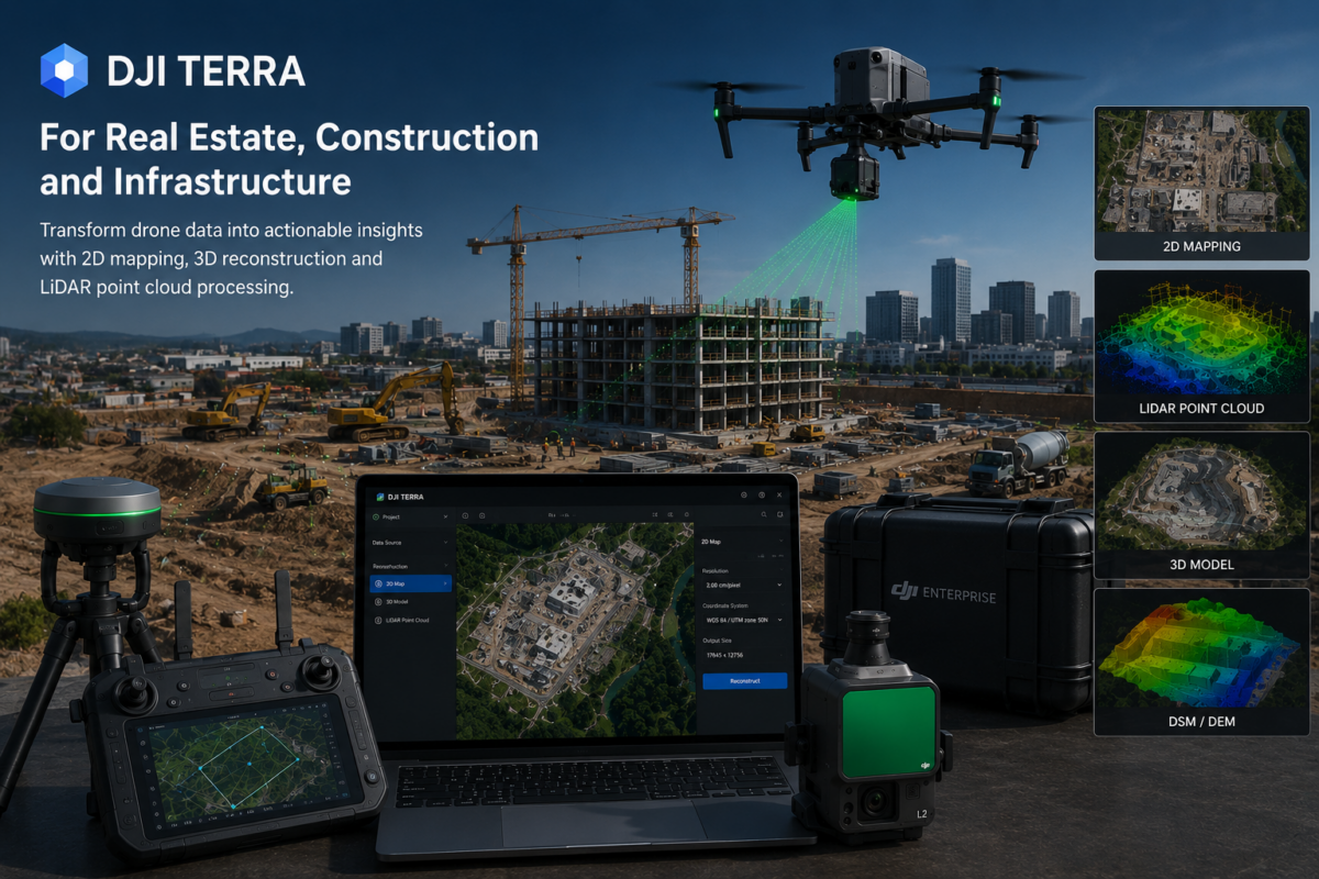
DJI Terra is becoming one of the most useful software platforms for professionals who need to transform drone data into practical digital deliverables. For real estate developers, construction companies, engineering firms, infrastructure operators and drone service providers, DJI Terra can help convert aerial imagery and LiDAR data into 2D maps, 3D models, point clouds, terrain outputs and realistic visual reconstructions.
In 2026, DJI Terra is no longer only a basic drone mapping tool. DJI presents Terra as 3D modeling software equipped with next-generation reconstruction technologies, including 3D Gaussian Splatting. It supports 2D and 3D reconstruction from visible-light imagery and can process data collected by DJI LiDAR systems. When integrated with DJI drones, Terra provides a unified workflow for data acquisition, processing and application.
This makes DJI Terra especially valuable for industries where visual documentation, spatial awareness, measurement, inspection and project communication are essential. Real estate teams can use it to present properties more effectively. Construction companies can monitor progress and compare site changes. Infrastructure operators can inspect assets, document conditions and build digital records of roads, bridges, towers, utilities and industrial sites.
In this article, we explore 10 practical use cases for DJI Terra in real estate, construction and infrastructure, explaining how each workflow can help professionals save time, improve communication and create more valuable deliverables from drone data.
What Is DJI Terra?
DJI Terra is DJI’s professional software for drone mapping, 2D reconstruction, 3D reconstruction, LiDAR point cloud processing and advanced 3D visualization. It is designed to work closely with DJI Enterprise drones and payloads, creating a streamlined workflow from aerial data capture to final output.
Depending on the project and license, DJI Terra can be used to create:
- Orthomosaic maps
- 3D models
- Point clouds
- LiDAR reconstructions
- Digital surface models
- Digital terrain models
- Visual site reconstructions
- Photorealistic 3D outputs using 3D Gaussian Splatting
For real estate, construction and infrastructure professionals, the value of DJI Terra is not only in the software itself. The value is in the workflow: capture the site with a DJI drone, process the data in DJI Terra, generate useful outputs, and use those outputs for planning, reporting, inspection, marketing or decision-making.
Why DJI Terra Matters for Real Estate, Construction and Infrastructure
These three industries have one thing in common: they all depend on accurate and understandable information about physical spaces.
Real estate needs strong visual presentation and site context. Construction needs regular progress monitoring and documentation. Infrastructure management needs inspection, asset mapping and condition assessment. In all three cases, drones can capture data quickly, while DJI Terra can turn that data into maps, models and digital assets.
Traditional photos and videos are useful, but they are often limited. A single image shows one angle. A video shows movement, but not always measurable context. A processed 2D map, 3D model or point cloud gives teams a more complete understanding of the site.
10 Practical Use Cases for DJI Terra
1. Real Estate Site Visualization
One of the most immediate use cases for DJI Terra in real estate is site visualization. A drone can capture a property, development area, resort, commercial complex or land parcel, and DJI Terra can process the data into a 3D model or visual reconstruction.
This is useful because buyers, investors and stakeholders often struggle to understand a property from flat images alone. A 3D model provides spatial context. It can show the surrounding landscape, access roads, nearby buildings, terrain shape, parking areas, construction status and overall site layout.
For real estate developers, this can improve presentations and investor communication. For land sales, a drone-derived 3D model can make a property easier to understand remotely. For luxury properties or large estates, realistic 3D visualization can become a powerful marketing asset.
Best For
- Land development presentations
- Luxury real estate marketing
- Commercial property visualization
- Investor briefings
- Remote property review
2. Construction Progress Monitoring
Construction progress monitoring is one of the strongest practical applications of DJI Terra. A drone can fly the same site regularly, while DJI Terra processes the captured images into orthomosaics, 3D models or point clouds. This allows project teams to compare progress over time.
Instead of relying only on manual site photos or written reports, construction managers can use updated aerial maps and 3D reconstructions to see what has changed. This can help identify delays, verify completed work, document site conditions and improve communication with clients or contractors.
Regular drone mapping can be especially useful for large construction sites, where walking the entire area may take significant time. A processed map gives a quick overview of the whole project.
Best For
- Weekly or monthly construction reporting
- Site progress comparison
- Contractor coordination
- Client updates
- Remote project monitoring
3. Earthworks and Terrain Documentation
Construction and infrastructure projects often involve significant earthworks. DJI Terra can help document terrain conditions before, during and after construction activities. Drone data can be processed into maps, 3D models, point clouds or terrain-related outputs that help teams understand how the site is changing.
This is useful for road construction, industrial sites, quarries, land development, excavation areas and large civil works. A visual and spatial record of earthworks can support planning, communication and verification.
For professional surveying or engineering use, outputs should always be checked and validated according to project accuracy requirements. However, DJI Terra can provide a practical and efficient way to generate terrain documentation from drone flights.
Best For
- Excavation monitoring
- Cut-and-fill documentation
- Quarry and stockpile context
- Road construction projects
- Pre-construction site surveys
4. Infrastructure Inspection and Asset Documentation
Infrastructure assets such as bridges, roads, towers, railways, industrial plants, solar farms and utility corridors need regular inspection and documentation. DJI Terra can help create 3D models, point clouds and maps that provide a digital record of these assets.
A 3D reconstruction can help inspection teams understand asset geometry and surrounding conditions. A point cloud can support technical analysis. An orthomosaic can provide an overview of the site or corridor. When combined with high-resolution inspection imagery, these outputs can improve documentation and reporting.
DJI Terra is especially useful when the organization already uses DJI Enterprise drones and payloads. The integration between hardware and software can simplify repeated inspection workflows.
Best For
- Bridge inspection context
- Road and railway documentation
- Utility corridor mapping
- Industrial facility records
- Solar farm and wind farm monitoring
5. LiDAR Point Cloud Mapping
For infrastructure, construction and terrain projects, LiDAR can be extremely valuable. DJI Terra can process data collected by DJI LiDAR systems, making it useful for point cloud reconstruction and terrain-related workflows.
LiDAR point clouds are especially helpful in environments where photogrammetry may struggle, such as vegetation, complex terrain, powerline corridors or structures with limited visual texture. For construction and infrastructure professionals, this can provide a more complete 3D understanding of the site.
LiDAR outputs can support road planning, forestry, utility inspection, terrain modeling, quarry documentation and corridor mapping. For professional use, point cloud accuracy should be verified with proper control and quality checks.
Best For
- Powerline and utility corridors
- Forested infrastructure routes
- Complex terrain mapping
- Quarries and mines
- Road and railway corridors
6. Digital Twin Creation
Digital twins are becoming increasingly important in real estate, construction and infrastructure management. A digital twin is a digital representation of a physical asset or site that can be used for monitoring, planning, communication and analysis.
DJI Terra can support digital twin workflows by generating 3D models, point clouds and realistic visual reconstructions from drone data. When flights are repeated over time, teams can update the digital record and monitor changes.
For real estate, a digital twin can support marketing and asset management. For construction, it can support progress tracking. For infrastructure, it can help document asset condition and support maintenance planning.
Best For
- Large building complexes
- Industrial sites
- Campuses and facilities
- Infrastructure asset management
- Smart city and urban planning projects
7. 3D Gaussian Splatting for Visual Presentations
One of the most interesting developments in DJI Terra is 3D Gaussian Splatting. DJI describes Terra as including next-generation reconstruction technologies such as Gaussian Splatting, which can help create detailed and realistic 3D models from photos.
For real estate and construction, this can be very powerful. Traditional technical outputs such as point clouds and meshes are useful, but they may be difficult for non-technical clients to understand. A more realistic visual reconstruction can make a site easier to present.
Real estate developers can use realistic 3D scenes to show a property or development. Construction companies can use them to explain site progress. Infrastructure teams can use them to provide visual context for inspections and planning.
Best For
- Investor presentations
- Client-facing project updates
- Real estate marketing
- Digital twin visualization
- Public communication and stakeholder review
8. Roof, Facade and Building Documentation
Buildings are among the most common subjects for drone mapping. DJI Terra can help create 3D models and visual reconstructions of roofs, facades, courtyards and surrounding areas. This can be useful for real estate documentation, construction quality control, renovation planning and inspection workflows.
For good building reconstruction, drone operators should capture both nadir and oblique imagery. Top-down images are useful for roofs and site maps, but oblique images are needed to reconstruct vertical surfaces such as facades.
Building documentation can support many professional activities, from property condition records to renovation planning and facility management.
Best For
- Roof condition documentation
- Facade inspection context
- Renovation planning
- Building portfolio management
- Insurance and damage assessment
9. Site Logistics and Access Planning
Drone mapping is not only about final models. It can also help teams understand how a site is organized. DJI Terra outputs can support site logistics planning by showing access roads, storage areas, crane positions, temporary structures, parking zones, excavation areas and material movement routes.
This is particularly valuable in construction and infrastructure projects where site organization changes frequently. A current orthomosaic or 3D model can help managers coordinate activities and reduce misunderstandings.
For large real estate developments, site logistics maps can help contractors and investors understand the current state of the project.
Best For
- Construction access planning
- Crane and equipment coordination
- Material storage documentation
- Safety planning
- Temporary road and site layout review
10. Client Reporting and Stakeholder Communication
One of the most practical benefits of DJI Terra is improved communication. Maps, models and 3D visualizations can make technical information easier to understand for clients, investors, public agencies and internal teams.
A construction manager may use an orthomosaic to show site progress. A real estate developer may use a 3D model to present a development area. An infrastructure operator may use a point cloud to explain asset conditions. A public agency may use drone mapping outputs to communicate project status to stakeholders.
Good communication can reduce delays, improve transparency and increase client confidence. This is often where drone mapping produces immediate business value.
Best For
- Monthly project reports
- Investor updates
- Public infrastructure communication
- Internal technical reviews
- Client deliverables and presentations
DJI Terra Use Cases Summary Table
| Use Case | Main Output | Best Industry | Business Value |
|---|---|---|---|
| Real Estate Site Visualization | 3D model or visual reconstruction | Real Estate | Improves property presentation and remote review |
| Construction Progress Monitoring | Orthomosaic, 3D model, point cloud | Construction | Tracks site changes over time |
| Earthworks Documentation | Terrain model, point cloud, map | Construction / Infrastructure | Supports excavation and terrain monitoring |
| Infrastructure Inspection | 3D model, point cloud, orthomosaic | Infrastructure | Creates digital asset records |
| LiDAR Mapping | LiDAR point cloud | Surveying / Infrastructure | Captures complex terrain and corridors |
| Digital Twin Creation | 3D model, point cloud, visual scene | All three | Supports long-term asset management |
| 3D Gaussian Splatting | Photorealistic 3D visualization | Real Estate / Construction | Improves client presentations |
| Building Documentation | 3D model and visual record | Real Estate / Construction | Supports inspection and renovation planning |
| Site Logistics Planning | Orthomosaic and site model | Construction | Improves coordination and planning |
| Client Reporting | Maps, models and visual deliverables | All three | Improves communication and transparency |
Which DJI Terra License Should Professionals Consider?
The right DJI Terra license depends on the workflow. Users focused mainly on standard 2D mapping and regular 3D reconstruction may evaluate DJI Terra Standard. Companies needing advanced 3D workflows, LiDAR, Gaussian Splatting, inspection-related projects or more complete enterprise functionality may need to evaluate higher-tier options such as DJI Terra Flagship or other available packages.
Because DJI Terra licensing can vary by region, version and package, professionals should always verify which features are included before purchasing. This is especially important for users who need LiDAR processing, cluster processing, advanced 3D reconstruction or DJI Modify integration.
Best Practices for Better Results
To get the best results from DJI Terra, professionals should focus on the quality of field data capture. Software cannot fully compensate for poor image overlap, blurry photos, bad lighting or incomplete coverage.
Recommended best practices include:
- Use high image overlap for mapping and 3D reconstruction
- Capture oblique images for buildings and vertical structures
- Use RTK, PPK or ground control points when accuracy is required
- Keep lighting conditions as consistent as possible
- Plan repeatable flight missions for progress monitoring
- Validate outputs before using them for measurements
- Export deliverables in formats suitable for the client’s software
- Test the workflow on a small project before scaling to larger jobs
Final Verdict
DJI Terra is a practical and powerful tool for real estate, construction and infrastructure professionals who want to turn drone data into useful digital outputs. Its strongest value is the ability to connect drone capture, reconstruction, LiDAR processing and visualization inside a more integrated DJI workflow.
For real estate, DJI Terra can improve visual marketing, property presentation and site understanding. For construction, it can support progress monitoring, logistics planning, earthworks documentation and client reporting. For infrastructure, it can help with asset inspection, LiDAR mapping, digital twin creation and long-term documentation.
DJI Terra does not replace every CAD, GIS or engineering platform, but it can become a central part of the modern drone mapping workflow. For companies already using DJI Enterprise drones, it is one of the most practical ways to transform aerial data into business value.
Need help choosing the right DJI Terra license? Contact our team for professional guidance. We can help you compare DJI Terra Standard, Flagship, Agriculture, Cluster and DJI Modify options based on your drone model, project type, LiDAR needs and required deliverables.
FAQ: DJI Terra for Real Estate, Construction and Infrastructure
Can DJI Terra be used for real estate?
Yes. DJI Terra can be used to create 3D models, site visualizations and realistic reconstructions that help real estate developers, agents and investors understand properties and development areas more clearly.
How can construction companies use DJI Terra?
Construction companies can use DJI Terra for progress monitoring, orthomosaic generation, 3D site models, earthworks documentation, logistics planning and client reporting.
Is DJI Terra useful for infrastructure inspection?
Yes. DJI Terra can support infrastructure inspection by creating maps, 3D models and point clouds of roads, bridges, towers, industrial facilities, utility corridors and other assets.
Can DJI Terra process LiDAR data?
Yes. DJI Terra can process data collected by DJI LiDAR systems, making it useful for terrain mapping, corridor mapping, forestry, infrastructure documentation and complex 3D environments.
What is 3D Gaussian Splatting in DJI Terra?
3D Gaussian Splatting is a next-generation reconstruction technology supported by DJI Terra that can help create detailed and realistic 3D visualizations from photos. It is especially useful for presentations, digital twins and visual communication.
Can DJI Terra replace CAD or GIS software?
No. DJI Terra can generate valuable outputs for CAD and GIS workflows, but it does not fully replace CAD drafting, GIS database management or engineering design software.
Is DJI Terra good for construction progress reports?
Yes. DJI Terra is very useful for construction progress reporting because it can turn repeated drone flights into updated maps, models and visual site records.
Which DJI Terra license is best for real estate and construction?
The best license depends on the required outputs. Standard may be suitable for basic mapping and 3D reconstruction, while Flagship or other advanced packages may be needed for LiDAR, 3D Gaussian Splatting, advanced reconstruction or enterprise workflows.
Can DJI Terra help create digital twins?
Yes. DJI Terra can support digital twin workflows by generating 3D models, point clouds and realistic visual reconstructions from drone data. For complete digital twin management, additional platforms may still be required.
Do I need RTK or ground control points with DJI Terra?
RTK, PPK or ground control points are recommended when accuracy matters. For visual marketing or basic documentation, they may not always be necessary, but for surveying, construction measurement or infrastructure analysis, proper accuracy control is important.