DJI TERRA NEWS
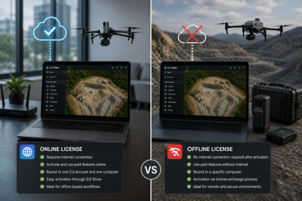
DJI Terra Offline License vs Online License: What Companies Need to Know
Choosing between a DJI Terra offline license and an online license is an important decision for companies using DJI Terra for drone mapping,
Read moreMay
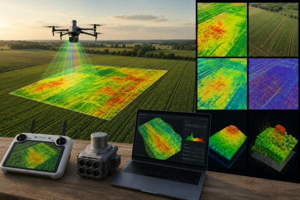
DJI Terra for Agriculture: NDVI Maps, Multispectral Data and Crop Monitoring
DJI Terra is not only a drone mapping and 3D reconstruction platform for surveying, construction and infrastructure. It can also play an important
Read moreMay
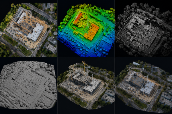
DJI Terra Outputs Explained: Orthomosaic, DSM, Point Cloud, Mesh and 3D Model
DJI Terra can generate several different outputs from drone imagery and LiDAR data, but many new users are not always sure what each
Read moreMay
DJI Terra for Matrice 4E: Why It Matters for Professional Drone Mapping
The DJI Matrice 4E is one of the most important compact enterprise drones for professional mapping, surveying, construction and mining workflows. Designed specifically
Read moreMay
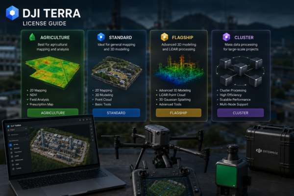
DJI Terra License Guide: Standard, Flagship, Agriculture and Cluster Versions Explained
Choosing the right DJI Terra license can be confusing, especially for new users who are trying to understand the differences between Standard, Flagship,
Read moreMay
3D Gaussian Splatting in DJI Terra: Why It Could Change Drone Modeling
Drone modeling is entering a new phase. For years, professional drone mapping has mainly focused on orthomosaics, point clouds, textured meshes, digital surface
Read moreMay

DJI Terra for Real Estate, Construction and Infrastructure: 10 Practical Use Cases
DJI Terra is becoming one of the most useful software platforms for professionals who need to transform drone data into practical digital deliverables.
Read moreMay

Can DJI Terra Replace Traditional Surveying Software? What Professionals Should Know
DJI Terra has become one of the most important software platforms for professionals using DJI drones in surveying, mapping, construction, infrastructure inspection, mining,
Read moreMay

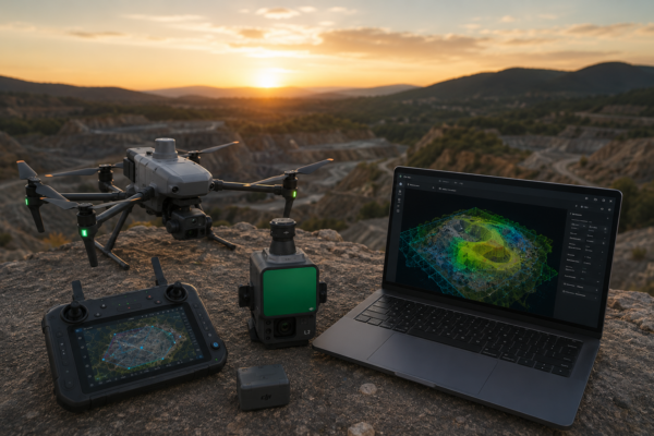
DJI Terra and Zenmuse L2: Complete LiDAR Workflow for Surveying
DJI Terra and Zenmuse L2 create one of the most practical LiDAR workflows available for drone surveying professionals. For surveyors, engineers, construction companies,
Read moreMay

DJI Terra vs Pix4D: Best Choice for DJI Enterprise Drone Users
DJI Enterprise drone users often face an important software decision: should they process their mapping projects with DJI Terra or Pix4D? Both platforms
Read moreMay

DJI Terra vs Agisoft Metashape: Which Software Is Better for Drone Mapping?
Choosing between DJI Terra and Agisoft Metashape is one of the most common decisions for drone mapping professionals, surveyors, construction companies, inspection teams
Read moreMay

DJI Terra for Beginners: How Drone Mapping Works from Flight to 3D Model
Drone mapping can seem complex at first. A drone flies over an area, captures hundreds or thousands of images, and somehow those images
Read moreMay

3D Gaussian Splatting in DJI Terra: The Future of Drone 3D Modeling?
3D Gaussian Splatting is becoming one of the most discussed technologies in drone mapping, reality capture and 3D visualization. With DJI Terra now
Read moreMay

DJI Terra, DJI Modify and DJI Reality: Is DJI Building a Full 3D Mapping Ecosystem?
DJI is no longer focused only on drones. In 2026, the company is increasingly building a complete ecosystem for drone mapping, 3D reconstruction,
Read moreMay

DJI Terra Adds New Reconstruction Features: Why It Matters for Surveyors
DJI Terra continues to evolve from a drone mapping application into a more complete reconstruction platform for surveyors, engineers, construction companies, inspection teams
Read moreMay

DJI Terra 5.2.0: What’s New for Drone Mapping Professionals
DJI Terra 5.2.0 is an important update for drone mapping professionals, surveyors, LiDAR users, inspection teams and companies working inside the DJI Enterprise
Read moreMay

Is DJI Terra Worth It in 2026? Pros, Limits and Best Use Cases
DJI Terra has become one of the most important software solutions for professionals working with DJI drones, aerial mapping, 3D reconstruction, LiDAR data
Read moreMay

DJI Terra Standard vs Flagship: Which Version Do You Really Need?
Choosing the right DJI Terra license is one of the most important decisions for drone professionals who want to turn aerial data into
Read moreMay